Distance: 13.1km (109.5km).
When walking a pilgrimage that in itself does not end at a cathedral, it is nothing but fitting to end at a natural cathedral instead. Looming above, but not visible from, Rjukan is the iconic Gaustatoppen. With its summit point at 1883m.

View towards Heddersvatn from the beginning of the climb up.
Measured by area, the summit of Gaustatoppen has the largest view in Norway. Under ideal conditions, it has a view of an area of 60 000 km², which corresponds to almost one sixth of the area of mainland Norway.

Looking up towards the summit of Gaustatoppen above.
In my original plan, I had thought to climb up to the summit from Rjukan, but that would almost certainly mean that I would have to spend another night in Rjukan. Not so bad, but due to another hike coming up and I would like to have at least one more day to prepare for it, I decided that I would like to go home today.

The view when looking back from the climb up to the summit.
As a result of this decision, I felt unsure if I had enough time to go all the way from Rjukan and up to the summit and get back down again to reach the last bus leaving for Oslo. I opted for the shuttle bus going up to the foot of the mountain. A minor defeat, but I must remind myself that this hike is about getting to the top and not what I experience on the way to my destination as I usually prefer.

Staircases of stone on the last climb up.
The weather is showing itself from its best side, with only shy clouds appearing on the blue firmament. I step off the shuttle bus at the entrance to Gaustabanen, the tramway leading up to the top of the mountain inside of it. If I am to take it, it will be on the return trip down.

The route to the actual summit of Gaustatoppen.
Gaustatoppen is, as mountain and peaks usually are, a huge pile of rocks. And the path up from the Gaustabanen entrance goes steeply up it. The most common path up to the summit begins from Stavsro, which becomes apparent as there are no other on the path I am coming up from, but there is a steady flow of people where I join the other path.

Looking back towards the telecommunication tower from the ridge on the way to the summit.
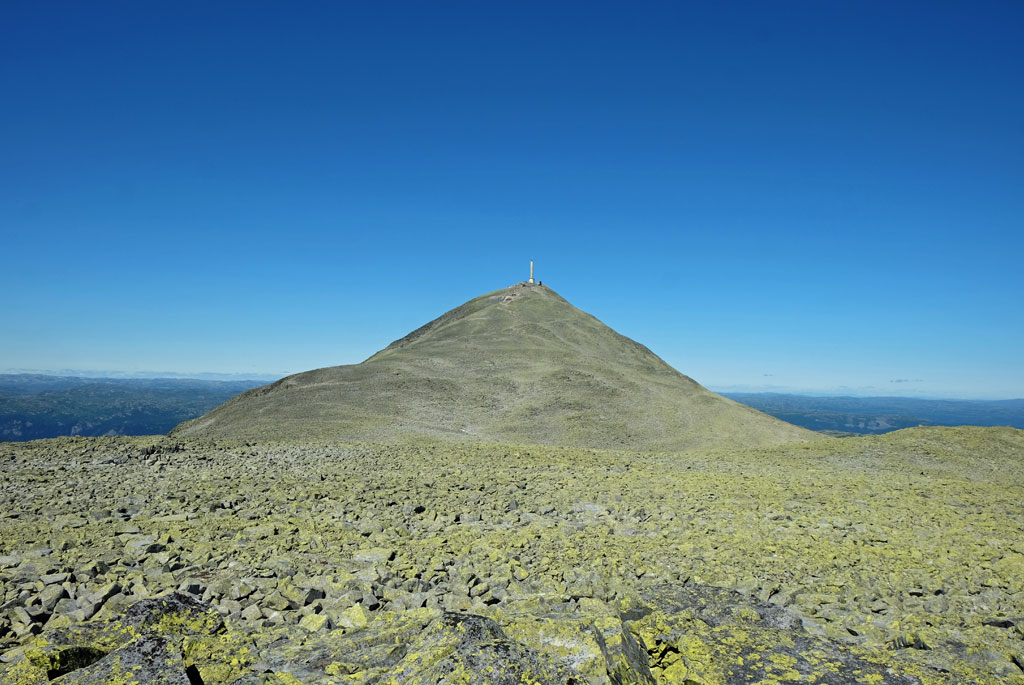
The top of the mountain is clearly visible all the way, at least in good weather. Mistakes cannot be made when a 68 meter tall telecommunication tower is stacked on top of it, making the top of the tower the highest point on the mountain at 1911m.
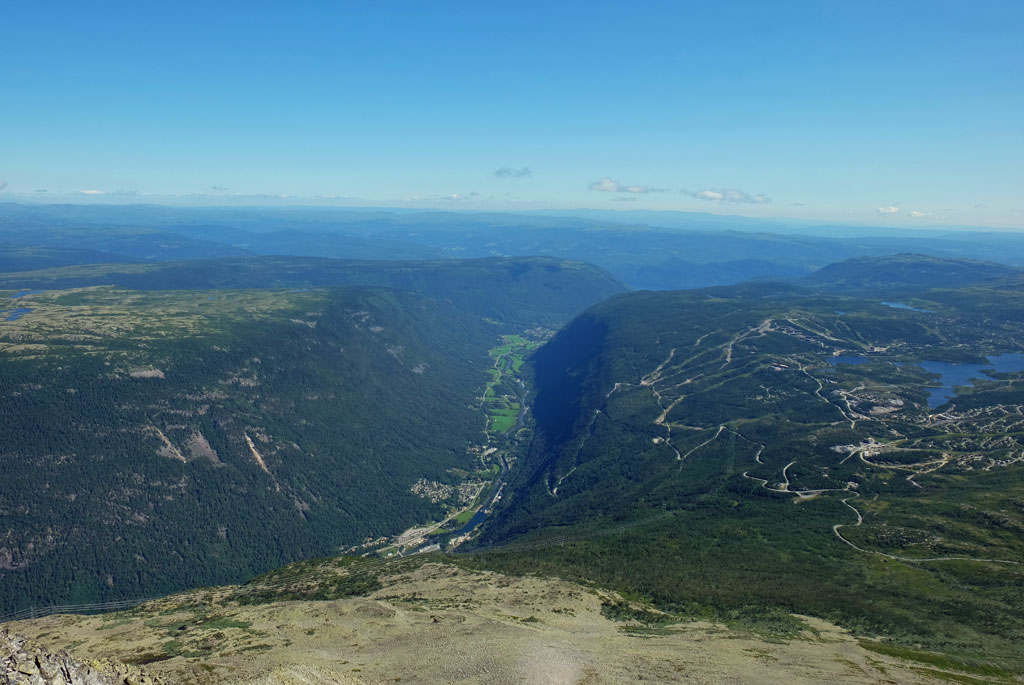
View of Vestfjorddalen and surrounding area and mountains from Gaustatoppen.
At the top, you also find the Gaustatoppen Turisthytte cabin. During the season, the cabin has food and drinks for sale. It is also possible the spend the night at the cabin (reservation required). Given the great weather, the summit area and cabin are naturally bustling with people.

Looking out from Gaustatoppen in the direction of the Hardangervidda plateau.
The actual summit, though, is not where the telecommunication tower and cabin are located. That is instead located a little bit further, reached by a slightly precarious ridge walk. Some scrambling is required to reach the summit at 1883m. Whether to go to the summit point or not depends all on your affinity for scrambling or the conditions, as the views are almost just as good from the platform next to the tower.

The sort of mandatory posing at the summit picture, not entirely knowing what to do with yourself.
Needless to say, the views are great. With the exception of all the mountains and peaks both near and far away, the most interesting is that I can look down at the Vestfjorddalen valley that I walked through yesterday and behind I can spot the tree covered hill of Mælsåsen.
Speaking of conditions. Gaustatoppen is also one of the most weather-hardy mountain peaks in Norway, making it ideal for the atmospheric icing phenomenon. No chance for it now, of course.

It is also interesting to look down from the summit.
After taking in the long-distance views, I scramble back to the cabin and order a coffee and a waffle. While eating and drinking, I sit and watch the long line of ants climbing up the mountain.

Here I look towards one of my favourite mountains in Norway, Skorve in Seljord.
Have a lot more time on my hand, so in order to prolong my time up here, I deviate from the trodden path and go explore the rocky and barren plateau of Gaustaråen. Taking the tramway down is out of the question now.

A line of ants.
Once I crest the small stony ridge above, the sounds from the other hikers on the path becomes muffled and eventually disappears. With no path, walking is more cumbersome, going over both smaller and larger rocks. In effect, the whole plateau is one big field of scree.
Gaustatoppen from Gaustaråen.
I cross over the scree, making sure not step on any loose rocks or boulders, doing a circle with the telecommunication tower at the summit of Gaustatoppen like a beacon to the North. I pass around one of the small lakes in the barren landscape, before turning back towards the path on top of the rocky crest on the eastern side.

Below Gaustatoppen lies Gaustaråen, a single large pile of rocks as well, although flatter.
The rest of the way down is by following in the steps of all the others in front of me, apart from a short detour to the top of Store Stavsronut and walking down from there instead. Most of the other people are happy and smiling being out in the nice weather, so I do not become frustrated by walking between large numbers of people (I usually prefer a more solitary experience when being out in the mountains or nature).

Looking up at Gaustatoppen from one of the small lakes at Gaustaråen.
At the café by the roadside, I order a local beer while waiting for the shuttle bus. And what other to order than the aptly named Gaustatoppen beer by Fjellbryggeriet.

On the way down towards Stavsro.
In hindsight, I believe that I would have had more than enough time to begin my hike to the summit of Gaustatoppen from the centre of Rjukan, but it is too late to whine about that now. The main goal today was still the view from the summit.

View from Store Stavsronut.
Back in Rjukan, I gather my belongings and find a place to eat before the bus back home leaves. Sitting on the bus to Oslo (have to change bus at Notodden), I reminiscence of my walk. From the west side of Tinnsjøen, I can look over towards the other side and see if I can make out the areas that I walked through.

Gaustatoppen beer.
For many, this walk might not be looked upon as a proper pilgrimage. Although the purpose of the pilgrimage is to visit the white churches around Tinnsjøen, it may not be considered sufficient in order of being a high enough of a religious motive for a pilgrimage. As I reckon, though, that might not be the original reasoning behind the walk. If you leave those thoughts behind, then you can find a pleasant walk and you can still find both a cultural and historical interest during it.
<< Rjukan // day 3


No comments:
Post a Comment