Showing posts with label De Kvite Kyrkjene. Show all posts

Friday, July 16, 2021

De Kvite Kyrkjene


De Kvite Kyrkjene is a short pilgrim path of about 90km in Telemark that goes around the Tinnsjø lake visiting six white churches on its way: Atrå, Dal, Gransherad, Austbygde, Hovin and Mæl. The pilgrim path runs on partly ancient paths or forest paths and rarely on asphalt.

In the summer of 2021, I found my way to the church at Gransherad to begin my pilgrimage of the white churches around Tinnsjø. Here you will find my tale:

Day 1 (12.07): Gransherad - Tinnoset
Day 1 (12.07): Krosshøl - Bråtadokktjønn
Day 3 (14.07): Buverudåsen - Rjukan
Day 4 (15.07): Gaustatoppen

Thursday, July 15, 2021

De Kvite Kyrkjene // day 4 // Gaustatoppen

De Kvite Kyrkjene pilgrim path, day 4.
Distance: 13.1km (109.5km).


When walking a pilgrimage that in itself does not end at a cathedral, it is nothing but fitting to end at a natural cathedral instead. Looming above, but not visible from, Rjukan is the iconic Gaustatoppen. With its summit point at 1883m.

View towards Heddersvatn from the beginning of the climb up.

Measured by area, the summit of Gaustatoppen has the largest view in Norway. Under ideal conditions, it has a view of an area of 60 000 km², which corresponds to almost one sixth of the area of mainland Norway.

Looking up towards the summit of Gaustatoppen above.

In my original plan, I had thought to climb up to the summit from Rjukan, but that would almost certainly mean that I would have to spend another night in Rjukan. Not so bad, but due to another hike coming up and I would like to have at least one more day to prepare for it, I decided that I would like to go home today.

The view when looking back from the climb up to the summit.

As a result of this decision, I felt unsure if I had enough time to go all the way from Rjukan and up to the summit and get back down again to reach the last bus leaving for Oslo. I opted for the shuttle bus going up to the foot of the mountain. A minor defeat, but I must remind myself that this hike is about getting to the top and not what I experience on the way to my destination as I usually prefer.

Staircases of stone on the last climb up.

The weather is showing itself from its best side, with only shy clouds appearing on the blue firmament. I step off the shuttle bus at the entrance to Gaustabanen, the tramway leading up to the top of the mountain inside of it. If I am to take it, it will be on the return trip down.

The route to the actual summit of Gaustatoppen.

Gaustatoppen is, as mountain and peaks usually are, a huge pile of rocks. And the path up from the Gaustabanen entrance goes steeply up it. The most common path up to the summit begins from Stavsro, which becomes apparent as there are no other on the path I am coming up from, but there is a steady flow of people where I join the other path.

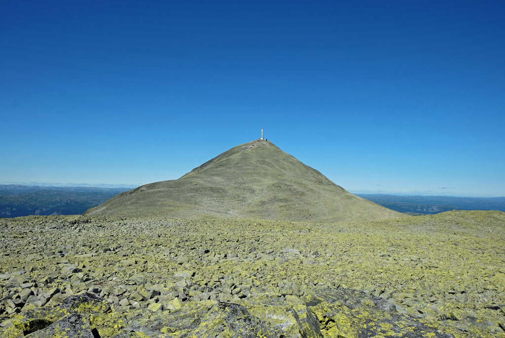
Looking back towards the telecommunication tower from the ridge on the way to the summit.

The top of the mountain is clearly visible all the way, at least in good weather. Mistakes cannot be made when a 68 meter tall telecommunication tower is stacked on top of it, making the top of the tower the highest point on the mountain at 1911m.

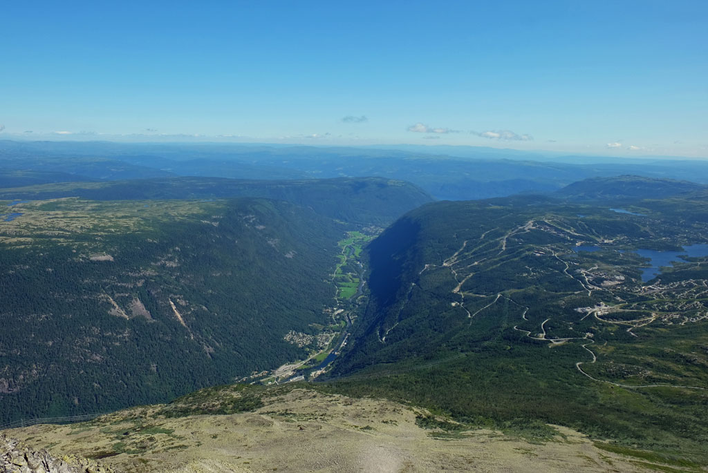
View of Vestfjorddalen and surrounding area and mountains from Gaustatoppen.

At the top, you also find the Gaustatoppen Turisthytte cabin. During the season, the cabin has food and drinks for sale. It is also possible the spend the night at the cabin (reservation required). Given the great weather, the summit area and cabin are naturally bustling with people.

Looking out from Gaustatoppen in the direction of the Hardangervidda plateau.

The actual summit, though, is not where the telecommunication tower and cabin are located. That is instead located a little bit further, reached by a slightly precarious ridge walk. Some scrambling is required to reach the summit at 1883m. Whether to go to the summit point or not depends all on your affinity for scrambling or the conditions, as the views are almost just as good from the platform next to the tower.

The sort of mandatory posing at the summit picture, not entirely knowing what to do with yourself.

Needless to say, the views are great. With the exception of all the mountains and peaks both near and far away, the most interesting is that I can look down at the Vestfjorddalen valley that I walked through yesterday and behind I can spot the tree covered hill of Mælsåsen.

Speaking of conditions. Gaustatoppen is also one of the most weather-hardy mountain peaks in Norway, making it ideal for the atmospheric icing phenomenon. No chance for it now, of course.

It is also interesting to look down from the summit.

After taking in the long-distance views, I scramble back to the cabin and order a coffee and a waffle. While eating and drinking, I sit and watch the long line of ants climbing up the mountain.

Here I look towards one of my favourite mountains in Norway, Skorve in Seljord.

Have a lot more time on my hand, so in order to prolong my time up here, I deviate from the trodden path and go explore the rocky and barren plateau of Gaustaråen. Taking the tramway down is out of the question now.

A line of ants.

Once I crest the small stony ridge above, the sounds from the other hikers on the path becomes muffled and eventually disappears. With no path, walking is more cumbersome, going over both smaller and larger rocks. In effect, the whole plateau is one big field of scree.

Gaustatoppen from Gaustaråen.

I cross over the scree, making sure not step on any loose rocks or boulders, doing a circle with the telecommunication tower at the summit of Gaustatoppen like a beacon to the North. I pass around one of the small lakes in the barren landscape, before turning back towards the path on top of the rocky crest on the eastern side.

Below Gaustatoppen lies Gaustaråen, a single large pile of rocks as well, although flatter.

The rest of the way down is by following in the steps of all the others in front of me, apart from a short detour to the top of Store Stavsronut and walking down from there instead. Most of the other people are happy and smiling being out in the nice weather, so I do not become frustrated by walking between large numbers of people (I usually prefer a more solitary experience when being out in the mountains or nature).

Looking up at Gaustatoppen from one of the small lakes at Gaustaråen.

At the café by the roadside, I order a local beer while waiting for the shuttle bus. And what other to order than the aptly named Gaustatoppen beer by Fjellbryggeriet.

On the way down towards Stavsro.

In hindsight, I believe that I would have had more than enough time to begin my hike to the summit of Gaustatoppen from the centre of Rjukan, but it is too late to whine about that now. The main goal today was still the view from the summit.

View from Store Stavsronut.

Back in Rjukan, I gather my belongings and find a place to eat before the bus back home leaves. Sitting on the bus to Oslo (have to change bus at Notodden), I reminiscence of my walk. From the west side of Tinnsjøen, I can look over towards the other side and see if I can make out the areas that I walked through.

Gaustatoppen beer.

For many, this walk might not be looked upon as a proper pilgrimage. Although the purpose of the pilgrimage is to visit the white churches around Tinnsjøen, it may not be considered sufficient in order of being a high enough of a religious motive for a pilgrimage. As I reckon, though, that might not be the original reasoning behind the walk. If you leave those thoughts behind, then you can find a pleasant walk and you can still find both a cultural and historical interest during it.

<< Rjukan // day 3

Wednesday, July 14, 2021

De Kvite Kyrkjene // day 3 // Buverudåsen - Rjukan

De Kvite Kyrkjene pilgrim path, day 3.
Distance: 26.4km (96.4km).


As foretold, I wake up to a grey and slightly dull morning, but thankfully it has not started raining yet. I get to prepare breakfast and coffee, and then break camp while being dry. No mistakes are being made, though, it will rain today, which I am sure of. Going a long distance yesterday, makes for a shorter walk today, which will give me more time in Rjukan.

Layered creek on the path over Mælsåsen.

From my campsite somewhere on Buverudåsen and over towards Mæl church, the trail mostly follows forest tracks over the hill, but also some sections on footpaths. I find the waymarking a little bit sparse over this section, although I am confident that I am on the right path.

De Kvite Kyrkjene pilgrim path over Mælsåsen.

Not long after I start walking, the rain is starting too. Through the trees, the views I do get of Tinnsjøen becomes muddled, mixing with the grey veils on the sky. On an ascending track, there is a nice view back down towards Austbygde, laying heavily underneath the clouds. The trees above me are ominous looking.

View of Austbygde through the veil from the path.

At a viewpoint, where I get clearer views, it is almost impossible to see over to the other side of the lake, with the exceptions of small windows where contours are slightly discernible.

On an ascending track.

On a clear day, this route claims to give the walk a nice view of Gaustatoppen, but the guarantee for that is extremely low today. Although, the low clouds are getting a bit higher on the sky when I begin the descent from the hill. There are some mountain farms and pastures that the path passes by, but they are less visible from where I go.

Tinnsjøen almost hidden from view.

Of obvious reasons the final descent to Mæl church is far from being as illuminated as the descent to Atrå was yesterday. Here the path is wild and more cumbersome, but the reward this time is a nice walk down what also appear to be an old carriage track near the end, ending at an outcrop with a nice view over the valley. The viewpoint is called Håmaren.

The mountains on the other side of the valley.

Despite having been a wet walk, I am content with the day so far, but I do feel a bit cold when sitting down at Mæl church for a rest. From the church, built in 1839 next to the old stave church from 1180 (no longer existing), I can look over towards the ferry terminal at Mæl. That is where you are supposed to take the ferry to Tinnoset from at the start of this pilgrimage.

Descent towards Mæl church.

As the ferry terminal is of some historical interest, I pondered going over to take a look. There is however a lot of traffic on the road below, and getting to the ferry terminal involves walking on the very same road. I let it pass.

A good way to use the end of a fallen tree, waymarker on a log end.

The walk from Mæl church to Dal church, the last of the white churches around Tinnsjøen, is the section of the trail that I had the least expectations of. It will be the part that clearly involves the longest stretch going on a hard surface and for the most part stays down in the valley.

View of Vestfjorddalen from Håmaren.

And true to expectations, there are some kilometers walked on a hard surface after leaving the church. On the positive side, the rain has subsided, and there is almost no traffic on this road. Be aware that at the point of writing this, this part of the pilgrim path has not been fully waymarked yet (but by following the description in the guidebook it is pretty obvious where you should go).

Mæl church.

Things somewhat improve when getting to Miland school, where the path crosses the more trafficked county road and the Måna river. From the bridge the trail will follow this side of the river all the way to Dal church with the surface much milder on the feet.

The path next to the Måna river.

Next to the now more pleasant track are several colorful installations made by local children, trying to provide some hope during the current pandemic. Some of them are also quite hidden, so you have to look good to spot them all. Hidden eyes that smile up at you from the undergrowth.

Is there a troll staring up at me from the undergrowth?

Quite pleasant walking with the now prominent Gaustatoppen in view, although its summit is still shrouded by clouds. I eat lunch on a bench getting warmed by the sun now appearing on the sky.

Peek-a-boo!

I follow where the pilgrim path is said to go almost all the way but have to make a detour when the trail keeps closer to the woods while I want to follow the track going alongside the river.

Water over the causeway on Måna river.

The small Dal church dates back to between 1190 and 1215, and has been somewhat affected by the impact the industry has had on the Vestfjorddalen valley. This impact is clearly visible on the walk through the valley, which might marr the scenery. There is no escaping seeing all the power lines and power stations filling up the valley, but the industrial residue might be of historical interest too.

A walk with Gaustatoppen in view, although shrouded by clouds today.

For the final walk into Rjukan, I partly follow a local footpath called Månåstien. It is interesting how convoluted and narrow this valley is, with steep inclines on both sides effectively shutting out the sunlight for most of the day. To such a degree that they have built a sun mirror to project the rays of the sun into the town. No need for the mirror now, heavy clouds with interspersed rain are now drifting across the valley.

Waterfall, Kvitåe.

Although at times bereft of the sun, Rjukan is still a nice little town. The most imposing sight in the town is without doubt the huge and impressive Saaheim Kraftverk. This power station was built in 1914 and had 11 units with a capacity of 167 000 hp. It is owned and run by Norsk Hydro and has 188 MW installed power on three Francis turbines and an average annual production of 1022 GWh.

Dal church with the Rjukanbanen museum train passing by behind.

To sum up this day, the walk was not of the most exciting kind. I was most satisfied with the first part, finishing up the walk over the hill from Atrå, despite it being a wet affair. Although the walk from Mæl church had its pleasant sections and view of Gaustatoppen, it gradually became less interesting.

Rain across Vestfjorddalen.

In total, I am content with my pilgrimage to the white churches around Tinnsjøen. This is mostly due to some of the very nice paths that the trail is going on and except for the walk from Mæl church and through Atrå, very little of the walk is on roads. My favourite sections are the old church ways, the path down to Tinnsjøen from Rauadammen, the forest paths from Hafoss to Austbygde and the walk from Hovin church over Ramnskardåsen.

Rjukan church.

Of course, I am not totally done yet. I have one more cathedral to reach before I can say I am finished.

Saaheim Kraftverk.

<< Buverudåsen // day 2Gaustatoppen // day 4 >>

Tuesday, July 13, 2021

De Kvite Kyrkjene // day 2 // Bråtådokktjønn - Buverudåsen

De Kvite Kyrkjene pilgrim path, day 2.
Distance: 42.7km (70.0km).


The next church after Hovin is at Austbygde, some 30km between them. I have already eaten up some of those kilometres, so less to go. The day will however not be finished at Austbygde church, so more to go still. From Austbygde, the proposed route has been altered, a note at Hovin church told me that it was impossible to go down from the road the pilgrim way was going on to the church. This means that the walk up to Austbygde church from Austbygde will be a round trip.

Bråtådokktjønn in the morning.

That is still some hours away from when I wake up in my tent to a quiet lake in the morning. Even the annoying hoard of mosquitos and gnats from yesterday evening is quiet as I prepare my breakfast and morning coffee.

The path over Ramnskardåsen.

This part of the pilgrim path is following what is called Gamle Hovinvegen, an old way that now goes past pines, rocky outcrops, and bogs on its course over Ramnskardåsen. The walk is scenic and pleasant, a fine start to the walk of today.

More creek than path, this wet section was just before getting to the Sønstevatn lake.

When walking a trail that you at first hand was a little bit sceptic of, there is nothing better than to find out that you actually are enjoying yourself when you are walking it.

De Kvite Kyrkjene pilgrim path going past Bjortjønn.

Bjortjønn lake.

Coming down from the Ramnskardåsen hill, I find myself walking through an area with some scattered cabins around. The walk has changed from going on a foot path to a forest track as it passes by a string of lakes, Sønstevatn, Heivatn, Bjortjønn and Tovstjønn. Relaxing views for the eyes.

Tovstjønn with its tiny island.

Gamle Heie Skule is an old school the pilgrim path passes by, which stood ready for use in 1886. It provided education of the kids in the surrounding area until 1958 when it closed. For some the walk to the school was both long and steep. It is now being used as a school museum. Looking through the windows, I can see the old furniture from the time it was in use, musing on how different the education probably was in comparison to my own.

Telemark farms.

The old school house at Gamle Heie Skule.

This part of the pilgrim path follows gravel tracks, forest roads and some few paths in between. The path crosses over a creek called Lengstebekk (which translates to ‘The Longest Creek’). A short walk on a paved road (the same road we used to get to my starting point yesterday) has to be tolerated to get to the final section of the walk before reaching Austbygde. Fortunately, that section is a very pleasant one (not the walk on the paved road of course).

Lomtjønn.

Leaving the road, there is a short walk on a gravel track past the Hafoss lake with its cabins. Then crossing over a bog on what appear to be a makeshift boardwalk, and a nicely situated bench with a table in the middle of the bog, it is all forest paths. Midttjønn lake are visible through the trees, while the much larger Gjuvsjå is not.

Hafoss lake.

This is still the old Gamle Hovinvegen way. It is a lovely forest scenery. Sometimes, old and forsaken farms are visible next to the path. Three old bridges are used to cross over running water.

Crossing over a bog after Hafoss, passing by a picnic bench and table in the middle of it.

Gamle Hovinvegen old way.

Before the descent to Austbygde, a small detour takes me up to a hill called Verpenuten with a great view over Tinnsjøen. The detour is marked with a sign ('Utsikt'). Taking the short part on the paved road out of the equation, the walk so far today has been enjoyable. This is a nice addition to it.

A barn or a farm that appears to be no longer in use.

I have been walking a little over 5 hours when I arrive at Austbygde. This village provides the most in terms of services on the pilgrim path. For pilgrims or hikers, it is the food store and the local bakery that will be the primary targets. I stock up on some few supplies and food, then have my lunch at one of the picnic benches. Needed some drinks too, it has been a warm day. Before I continue, I grap a cup of coffee from the bakery.

The pilgrim path passes by these stones that appear to be some kind of old waymarks.

From Austbygde, the pilgrim path has been altered, as I had been given warnings of. Instead of going higher up on the road towards Veggli and then down to Austbygde church from there, you have to go up to the church and back again from the village centre. Normally, the pilgrim path stays higher up, not going down to the village, but people might have to go down anyway, if they are to find accommodation in Austbygde.

Great view over Tinnsjø from Verpenuten.

Going up and back the same way usually does not appeal to me, so I scour the map for possible other ways to go. I do find some options, but in the end, I decide to just follow the same way. It is not an unpleasant walk.

Alt blir bra ('Everything will be fine'), at Austbygde centre.

Before the church in Austbygde was consecrated in 1888, the people living here and in the Tessungdalen valley had to walk to Atrå to get to a church. Where there had been a church since around 1180.

Austbygde church.

On the path between Austbygde and Austbygde church.

If trying to figure out distances walked, the guidebook to the pilgrim path is a little bit confusing around here. As the book describes the walk in three chapters, a roundtrip from the centre of Austbygde to the church and back again, from Austbygde church to Atrå church and from the centre of Austbygde to Mæl church past Atrå church. With all the descriptions overlapping.

One of the 'Tinntrollene' wooden figures ('Tinn Trolls'), overlooking a nice view of Tinnsjøen from above Austbygde on the way towards Atrå.

The walk over to Atrå is a highlight of the day. Pleasantly getting higher up, the path opens up to nice views over Tinnsjøen. Situated next to the path at times, are small wooden figures called Tinntrollene ('The Tinn Trolls'). The best part of the walk is when the pilgrim path enters one of the old church ways ('Gamal kyrkjeveg') that people used to get to Atrå church. The path is wonderful and with a lovely light from the sun at this hour. Old stone walls were built to create this path, winding downwards over stones, moss and heather, also crossing over a bridge on its way.

The old church way to Atrå church with Tinnsjøen lake.

With a somewhat undecidedly plan of walking about 30km a day, this section was where I would have tried to find a place to camp, but I found it too early to stop. Plus, there is also a threat of bad weather tomorrow, so I wanted to see as much as I can before everything gets obscured. I push on towards Atrå.

'Gamal kyrkjeveg' path towards Atrå church.

It is strange to be so happy to see an open shop, but after walking for some time yearning for something other than water to drink, that is exactly what I am when I get to the shop in Atrå. Coming out of the woods, there was no escaping some walk on hard surface.

Atrå church.

The original old church in Atrå was a stave church dating back as far as around 1180. The church I see now was open to the public some 650 years later. Late is the day when I am here, almost half past eight.

Atrå.

Over to Mæl church the walk is similar to that from Austbygde, only that this path goes higher up. The evening sun is upon me as I head up into the hills above. A tunnel of vegetation at times, sometimes lit up by the evening illumination. Passing by a very old loft. Next to the path is a farm that appear forsaken with tall grass around.

A very old loft passed by on the way up into the hills between Atrå and Mæl.

An abandoned looking place or farm. Is there someone watching me from the windows??

After a somewhat steep climb up, I find myself on a forest track and I begin to search for a place for the night. There are some nice fireplaces, but with not so good places for my tent. In the end, I locate a place having to go a little bit down from the track. A sheltered spot between trees on a heather bed.

Evening sun illuminating the path up into Buverudåsen.

Looking back towards Atrå below from the evening climb up into Buverudåsen.

As the sun disappears behind the mountains with a last flare, I have my evening dinner and coffee. The day became a long day, and I am happy for it. It was rather exciting in a way. The Gamal Kyrkjeveg (‘The Old Church Way’) was the definite highlight of the walk, with its beautiful path and light.

Setting sun from my campsite at Buverudåsen.

<< Bråtådokktjønn // day 1Rjukan // day 3 >>

popular posts