Friday, September 24, 2021

Valldalsleden: A continuation of a pilgrimage

Valldalsleden.
Gjevilvatnet - Oppdal - Trondheim.
Distance: 254.7km. 11 days.


In the Winter of 1028-1029 Olav den Hellige was on the run from a more powerful king, Knut den Mektige. With a significant smaller fleet of ships, he set shore in Valldal and led his remaining faithful men over the mountains to Gudbrandsdalen and from there further on through Sweden to Novgorod. This is the backstory of Valldalsleden, the pilgrim path starting at Valldal, which connects with the Gudbrandsdalsleden path from Oslo at Dovre, ending at Nidarosdomen in Trondheim.

Evening sun over Gjevilvatnet.

Earlier in the summer, I had hiked Valldalsleden from its start at Valldal to Fokstugu. From there I had backtracked a bit on Gudbrandsdalsleden to Budsjord in order to hike Gaustigen, a lesser known trail and pilgrim path of old to Gautåsætrin at Dovre. From there, I had followed Gudbrandsdalsleden again over Dovre to Oppdal. At that time, I had not planned to continue further, as I had already done a through-hike of Gudbrandsdalsleden all the way to Trondheim from Oslo. In total I used ten days from Valldal to Oppdal.

Reindeers in Trollheimen.

When I had abandoned my plan to hike the Rondanestien trail back towards Oslo after finishing the Jotunheimstien trail, as I was not motivated to do it, I had struggled to come up with a replacement plan. Several ideas, both old and new, had come to my mind. Few resonated with me, and in the end, I had just decided upon completing Valldalsleden from Oppdal to Nidaros.
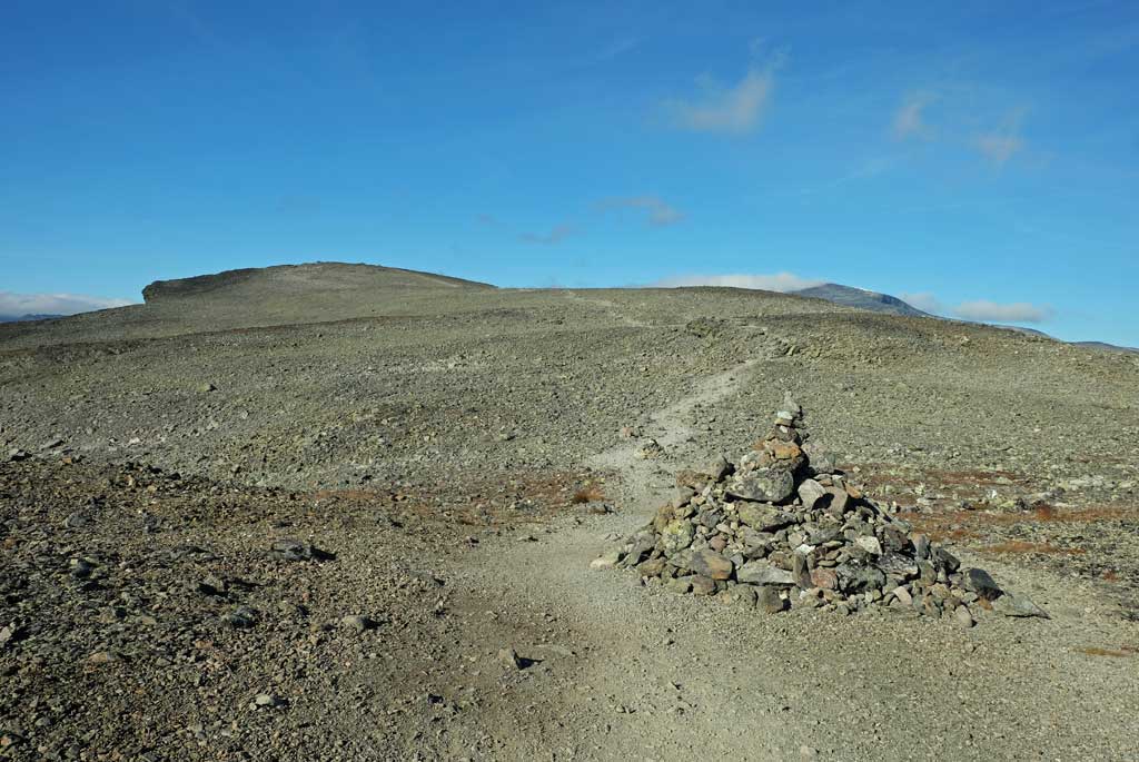
At Blåhøa.

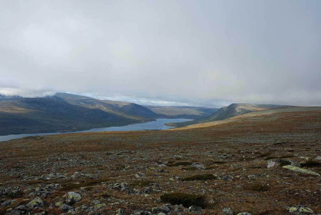
On the other hand, I was drawn to the mountains. Close to Oppdal lies Trollheimen, a mountain area with a very popular hike going through it. Three paths that forms a triangle known as Trekanten, starting from the Gjevilvasshytta cabin, and going to the Trollheimshytta and Jøldalshytta cabins before returning to the former cabin.

Typical scenery in Trollheimen around the Trollheimshytta cabin.

Arguably not a part of the pilgrim path to Trondheim at all, this hike felt a part of my trail.

Ascending up through the clouds towards Trollhøtta.

The weather was not to be my best friend on the hike through Trollheimen walking-wise, but it made for some wonderful dramatic scenery. I had a nice late hike up the area called Bruna in a wonderful evening sun upon arrival at the Gjevilvasshytta cabin, but the ensuing days was all about dramatic clouds and rain.

View from Trollhøtta.

Deep and low clouds lay heavy on the landscape as I hiked into the heart of Trollheimen, the landscape felt similar to the wildness of Scotland. Autumn colours coming to the fore. Reindeers running around. I met a couple of other hikers, whom I would meet again as they were doing the same hike as me.

The Trollhøtta massif reflected in a small mountain lake.

Voices in the air above prompted me to climb Blåhøa at 1672m, with clouds crashing into its sides like ethereal waves crashing into cliffs.

A bellowing reindeer buck.

Ancient and gnarled pines, and a landscape dominated by marshes surrounds the old Trollheimshytta cabin, with the low clouds adding fairy tales to my walk. The next day, after a cosy evening illuminated by carefully tended candles, I climb over the rocky peak of Trollhøtta. Below the summit at 1614m, the clouds were floating around the mountains like islands in an ocean.

Autumn in Trollheimen.

On the last day, a big reindeer ox bellowed loudly among his herd.

Gamle Kongeveg (the old Royal road) from Oppdal.

The hike through Trollheimen was dominated by the scattered rain and low clouds, with floating windows with views of the mountain landscape in between them. I did not miss a clear blue sky a bit. When speaking photography, this was far better.

The pilgrim albergue at Hæverstølen just as cosy as before.

Back in Oppdal I had continued my pilgrimage on the Valldalsleden path from earlier this year. As some might point out, I followed the Gudbrandsdalsleden path, but I see it more like that those paths are sharing the way the rest of the way to Trondheim and Nidaros.

Walking next to the Orkla river on the lower route of the pilgrim path before Stamnan.

The places that I walked through, though, was the same that I had walked through last year. Some of the nights, I slept in the same places as then. Other nights, I tried out other places. And while Sundet Gård was my preferred place to sleep on the last night, I had to find another accommodation as it was not possible to stay there this time.

View from Skruen above Voll, the peaks of Trollheimen in the background.

Hæverstølen, Meslo Gård and Gumdal Gård was the same hospitable and friendly places that I remembered from last year. New to me was Segard Hoel, another welcoming hostel for the pilgrims where they sleep in an old farm building.

Gamlebua at Voll.

Another change from last year was the sudden meeting of other pilgrims. Walking the Gudbrandsdalsleden path can be a very solitary walk. Last year, I walked for two weeks before meeting the first other pilgrim. This time, I got more company along the way, and it was welcome. Roll a dice and if you are lucky, it comes out with a lucky number. On the way to Trondheim, I got company from Rosalia from Italy and Daniel from Germany. Later on, I met Norman, also from Germany.

A grey weather awaited us out from Segard Hoel.

Last year, when I walked to Stamnan and Meslo Gård, I chose the path that went on the higher ground past Slipran. This time, I went for the lower path going next to the Orkla river. It was a nice walk, providing insights into the fishing opportunities in the river.

Medskogsvatnet, a small detour from the pilgrim path through Skaun leads you to this scenic spot.

When doing long distance trails, I often feel that one should not only pay heed to the places that one passes right next to, but make time to see what lies beyond them too. All within reasonable distances of course. Before I arrived at Voll, I went up to Skruen. A steep, but rewarding climb that provided me with some great views over the landscape hidden from my sight while walking down in the valley. Best of all was the view over the peaks of Trollheimen in the distance.

Lykkestien ('The Happiness Trail') at Øysand.

On the last night before I arrived in Trondheim, the northern lights had danced across the dark sky, like ethereal pilgrims high above.

A tunnel of vegetation at Gaula.

Trondheim was the same as last year. As was Nidarosdomen, the cathedral where you find the tomb of Olav den Hellige. Although, this time, I had got company when celebrating the end of my pilgrimage. Together with Rosalia, Daniel and Norman, I had a good dinner at a restaurant in Trondheim.

Pipes of the organ and the rose window in Nidarosdomen.

To me the hike through Trollheimen was spectacular due to the weather and was the highlight of this journey, although I was satisfied with the pleasant continuation and fulfilment of Valldalsleden. Nothing new, but in some ways, I just had some relaxing days out walking and maybe that was all I needed at this time.

Out celebrating in Trondheim, Norman, Daniel, me and Rosalia.

Sunday, September 5, 2021

Jotunheimstien // day 13 // Veslfjellet

Jotunheimstien, day 13.
Distance: 10.5km (356.5km).


I had finished my through-hike of the Jotunheimstien trail, but I had still some time left before I would travel back home again.

That is correct, for eventually I had ended up deciding not to go through with my plan. I will come back later with a short review of the Jotunheimstien trail, but for now let us focus on what I most felt afterwards was that most of the trail had eventually felt the same. I had seen the same forest, hills and bogs over and over again.

The prospect of spending another 300km of seeing the same forest and bogs, after the initial highlight of Rondane, did not appeal to me given my lack of motivation from the start of my hike. Maybe I will return again to do the Rondanestien in some years, but for now I had no interest in doing it.

Killing time before homeward bound was done by climbing up to the summit of Veslfjellet. As most other walkers hiking over the Besseggen ridge are taking the boat to Memurubu and walking back to Gjendesheim I had thankfully escaped most of the throng doing the hike.

I had turned back just after the summit of Veslfjellet, with great views over Gjende surrounded by the jugged peaks of Jotunheimen, tempted to just continue down the edge of the Besseggen ridge.

Back at Gjendesheim, I sat down for a beer before I walked down to the campsite at Maurvangen where I had met the father and sons who also had stayed at the Oskampen cabin. One of the sons lived in Oslo, so I had been so fortunate to get a lift back home.

Cabin and boathouse at Gjendeosen.

Gjende.

Up towards Veslfjellet on the stony plateau at its top.

Looking down at Gjende with Gjendehøe and Knutshøe behind.

Steep outcrop at Veslfjellet, with views down towards Gjendeosen and Gjendesheim below.

As I had struggled to come up with a trail that I really wanted to do this year, my motivation had suffered. Last year was no problem, it was obvious that I wanted to experience the pilgrim path in Norway to Trondheim, but there were no real alternatives left that I really felt interesting for this year.

I had considered doing the Østerdalsleden to Trondheim, but found that doing another pilgrimage to Trondheim was not what I wanted the most. In the end, I had come up with the plan to do both Jotunheimstien and Rondanestien after considering several other options. Which included a plan to make my own trail so to speak.

I had not been properly motivated for it.

So then my verdict should be seen with that in mind. In itself, each day had been nice, but in the end, they begun to feel the same. That said, I did not have a bad time on the trail.

As the trail had finally moved up into the mountains, things had improved, but the damage had been done.

However, one thing that remains with me after the hike is all the old farmsteads, both still in use and apparently abandoned, which I found particularly fascinating. Some with views, some secluded deep in the woods, all with histories probably to be told. The toil of old.

Jotunheimen.

Looking down at Gjende from Veslfjellet with the peaks of Jotunheim all around it, Bukkehåmåren and Høgdebrotet to the left.

A solitary red t waymarker in front of Bessvatnet with Bessfjellet behind.

Looking back towards Jotunheimstien on the way down from Veslfjellet, Sikkilsdalshøa in the background.

Old farms at Gjendeosen.

It is written that the Jotunheimstien trail is following the footsteps of old Norwegian writers and artists, maybe this is best seen through these old farmsteads along the way.

<< Gjende // day 12

Saturday, September 4, 2021

Jotunheimstien // day 12 // Oskampen - Gjende

Jotunheimstien, day 12.
Distance: 27.2km (346.0km).


It had been a beautiful morning to wake up to. Rime on the grass outside. Sun rising warm in the East. Mountains reflecting in the mirror calm lakes below. And cows looking stupidly at me just outside the windows.

The final day on the Jotunheimstien trail and its terminus at the Gjendesheim cabin, and at the end it was just as I had expected it to be. Seeing more people at once than I had combined on all the days on the trail. The price of being close to the hike everybody puts their pride in doing, Besseggen.

I had spent more time than usual after setting forth from Oskampen, the views had been too nice to walk quickly past them. It was quiet, and the clouds floating over Austhøi was perfectly reflected in the calm waters of the small lake nearby the cabin.

Those clouds floating over Austhøi had however continued their journey as I had hiked down to the cabins at Nedre Heimdalen and begun my climb up towards the highest point on the Jotunheimstien trail.

As I had hiked up towards the pass between Såta and Vangstulkampen, the clouds had almost covered my ascent and I had expected a foggy hike over the pass.

That did not happen and when I had crossed the highest point of the trail at approximately 1421m, I had great views of the landscape ahead. Still clouds around me of course.

At Sikkilsdalsseter with a view of the gathering of horses, I took a short break where I had treated me to a beer brewed by the hosts at the mountain farm.

Rime outside Oskampen.

Reflections of clouds drifting over Austhøi in the small lake outside the Oskampen cabin.

Nedre Heimdalsvatnet from the climb up towards Vangstulkampen.

At the highest point of the Jotunheimstien trail (although I was to be higher up at a later point).

Sikkilsdalen, Sikkilsdalshøa to the right.

After Sikkilsdalsseter it is where the intrepid hiker will meet an enigma of the trail. The sort of official route of the trail goes down alongside the two Sikkilsdalsvatnet lakes, but any with local knowledge of the area knows that the path going over Sikkilsdalshøa is by far the most spectacular of the two ways towards Gjende.

Faced with the dilemma of leaving the trail or not, having hiked the beautiful path over Sikkilsdalshøa before, I had still decided upon the higher ground.

The crossing over Sikkilsdalshøe was by far the highlight of the whole trail. I had ventured off the path to gaze down from the steep sides of the mountain, marvelling at the sheer drop I had looked down from.

At the summit, the views are of Gjende with Jotunheimen in all its glory behind. The words are about Besseggen, but this is a just as great a hike if not better, with fewer people.

Went through several herds of reindeers on the way down.

The final section had been as expected not so enticing, having walked through the campsite and up alongside the road (on the path though) towards the end of the trail at Gjende.

It was a little bit shock to the system to arrive at the Gjendesheim with all the people present, but I had been prepared for it. Irony being having to sit alone at the dinner table due to the still present corona rules.

A steep look down from the side of Sikkilsdalshøa.

Jotunheimene with Gjende from Sikkilsdalshøa.

Reindeers and Jotunheimen.

Reindeer.

At the end of the Jotunheimstien trail, the Gjendesheim cabin at Gjende.

I felt I had earned a good dinner and a good beer, having hiked from Oslo to Jotunheimen (although with a break in between).

<< Oskampen // day 11Veslfjellet // day 13 >>

Friday, September 3, 2021

Jotunheimstien // day 11 // Storkvolv - Oskampen

Jotunheimstien, day 11.
Distance: 26.4km (318.8km).


On the penultimate day on Jotunheimstien, I had walked to the Oskampen cabin.

The day had started all so unexpectedly, as I had woken up to a grey and shrouded weather outside, with imminent rain approaching. Quite contrary to the forecast I had received at Liomseter, which was for all good weather, but then again. Weather can change fast in the mountains.

Initially, I had been a little bit disgruntled when the rain had started, having felt annoyed that I should get the worst weather on the trail in the best part of it. I had, however, soon gotten over it and started enjoying my walk. Despite the low clouds and rain drifting across the landscape, the views were nice.

It even had added some dramatic flair to it.

I had hiked here before, some years ago, but in this weather, there were not much that I could remember from that time.

Storkvolvbua in the morning, last light before the rain.

Rain over Langsua.

An opening appears in the rain, revealing mountains in the distance.

Rainbow before Storhøpiggen and Storhøa.

Clouds and light, Brennhøa.

At least not until the rain had started abating and blue sky had pierced through the clouds, spawning rainbows over the Svarttjønn lake. Storhøpiggen (1434m) and Storhøa (1420m) lies behind and I remembered that I had walked between those two peaks in my previous hike here.

I had lunch at the DNT cabin in the old farm of Storhøliseter, while drying up a little after the rain. This is a cosy little cabin with a nice farmyard outside, overlooking the boggy expanse the trail crosses over afterwards.

Before the path reaches Øyangen, it traverses a section of bogs and marsh land, getting my shoes wet was unavoidable. Of the final walk to Oskampen, this had been the most memorable, as I had not felt that excited about the walk next to the Øyangen lake.

While I had walked next to the lake, I could see that it was still raining to the south of me. Here I had walked underneath the sun and it had got warm.

Crossing over Vinstra with Storhøliseter and Storhøpiggen behind.

On the path towards Øyangen.

Langtjønna.

Oskampen cabin.

Sunset at Oskampen.

Cows had watched my final steps to the cabin. And almost for the first time on the trail, there were other people where I was staying. A father with his two sons, all grown-ups, were also staying at the cabin, which made for a social evening (probably for the greater good, preparing me for the next evening, when I would be at the Gjendesheim cabin).

<< Storkvolv // day 10Gjende // day 12 >>

popular posts