Showing posts with label Baekdudaegan. Show all posts

Tuesday, November 18, 2025

A look back at the Baekdu Daegan: Seoraksan

In this post, I look back at a memorable moment from one of my earlier walks, this time the Baekdu Daegan in South-Korea. I hiked this trail in 2014 that in the last days took me through the stunning Seoraksan National Park.

Seoraksan National Park, Baekdu Daegan, 2014.

Read about my walk on the trail here: Baekdu Daegan.

Wednesday, August 22, 2018

Ganbaeksan secret camp - Paektusan secret camp

North Korea / DPRK: Paektusan Highland Trekking Expedition, day 5.
Weather: Slightly overcast, but nice.


Never once did I wake up to the sound of rain on the tent, I took that as a good sign. And although we could see clouds lying seemingly dormant above our heads when we wake up, hope lay in the clear sky at the end of the valley. It is an early morning and breakfast for us. Today there is no mercy, we will hike or not, but our little gamble yesterday seems to have paid off. However, we now have to walk both day four and five in one. I am not worried though, in terms of distance, we have not walked very long each day so far.

Morning views from our campsite, there is light in the horizon.

Finally we leave our campsite for the last two nights behind and follow our local guides on a narrow and barely visible path. We aim for a pass between Beondaebong and Seonosan. Above us, the clouds has thinned out to become veils across the sky. I think the whole group is happy to be on the way again, as we all eagerly walks over the rolling meadows before the pass. The ascent is similar to the one up towards Ganbaeksan, but shorter and not as steep. And, of course, we now have visibility.

Young Korean students on a revolutionary march towards Ganbaeksan secret camp.

From the open pass between the two mountains, we can look down at the closed valley of our campsite. The secret camp hospital is still visible. Behind the ridge above the secret camp is the peak of Soyeonjibong rising up. The secret camps in this area is used for domestic tourism by high school students from all over North Korea, doing a revolutionary march between the various camps. On the pass, we encounter such a group. It is quite amusing, as they appear surprised to see us. As we smile and greet them, with Roger throwing in some Korean sentences, they all smiles and waves back at us.

The Baekdu Daegan ridge from Beondaebong.

Paektusan seen from Beondaebong.

With the sounds of the receding high school students, we set forth towards Beondaebong. At first climbing up over a round crest through sparse trees and vegetation. Mostly small pine trees, but we also pass through a short cluster of birch trees. Now it is definitely clear that we made the right decision yesterday to wait. As we gain elevation, the northern high plateau is revealing itself to us with Paektusan looming behind.

View from the top of Beondaebong. Paektusan at the back. The flat top of Seonosan below, and below that again to the right is the closed valley where our campsite was.

Jo is as usually the first of us up ahead. Unfortunately for one of the guides, who then has to keep up. The rest of us seems more content with taking our time and enjoying the surroundings. Beondaebong appear mostly like a round, bald and grassy peak. Actually, most of the nearby mountains here looks like tall, undulating grassy hills. The views from the top are great, with no obscuring clouds. From here on the Baekdu Daegan will continue on its course south through both North and South Korea, crossing over Ganbaeksan on the way. From here we can actually continue hiking on the ridge and arrive at Paektusan secret camp, a far more scenic alternative than the road we are to take, but we did not get the permissions to do so. Looking down from the peak, we can see the trace of the Amrok river that we will follow instead, with China on the other side.

The group at Beondaebong, me, Jo, Sinead and Paula.

Our guides, Mr. Choi and Mr. Hwang, taking a rest at Beondaebong. Remnants of a tree can be seen at the bottom of the picture.

There are also traces of the volcano eruption here. Erosion has started to uncover old trees, or rather the remains of them, broken tree stubbles standing up from the ground. I was wondering about these as we now appear to be above the treeline. Walking down from Beondaebong, I can see two other people walking down from another part of the ridge. One of them is doing a flip-flop, so my guess is that they are students or maybe young military.

View from the ascent of Seonosan, the closed valley where we camped below and at the back, Soyeonjibong peak.

The approach to Seonosan is far steeper than the impression of it is, as the top looks relatively flat when viewed from Beondaebong (Seonosan at 1985m is lower than Beondaebong). The top of Seonosan is a flat, grassy land of shrubs and sparse vegetation. I had hoped that we hiked over to what appears as a peak at the back of the mountain, with Paektusan at the back, but we are turning away from that direction. Instead, we arrive at a better viewpoint. This section of the mountain overlooks the border river of Amrok.

Looking back towards Beondaebong and the pass below from Seonosan, Sinead, Paula and Roger on the way up.

The crest of Seonosan that we got to walk over to. China can be seen behind.

Maybe not to the best liking of the guides, Jo, Sinead and I get to go on our own over to a crest that has a large open area with no trees beneath it. On the way, we wade through tall grass. There are trees here, but they stand separated from each other, giving it a ghostly feeling, only the end of the branches looks to have any leaves. Beneath us, the Amrok river is more or less making a gash in the landscape, the river seems to be burying itself down into the ground. Next to the river, we can see the old sealed gravel track that we will walk on later. A camp near the Seonosan secret camp is visible, with parts of the secret camp just in view. It is also clear from our viewpoint, that this side of Seonosan has a lot more rock formations and cliffs than we believed it to have.

View from Seonosan. From here we can see the Amrok river that forms the border between North Korea and China. A camp used by Koreans when visiting the secret camps here, and a brief view of Seonosan secret camp below.

The descent from the pass down towards Seonosan secret camp is on a steep and muddy path through the trees. If we had gone hiking yesterday, this path would be really slippery and treacherous and caution would be needed. Again is Jo in front of us, eager to go. To fast, it appear at one point, so two of the guides are starting to run down to keep him from going too far away. Leaving me alone on the track. This forest has a native feeling about it. We come down to a clearing with rolling grass, with the campsite we saw from Seonosan visible through the trees. This is one of the camps the young students stay at when they are on their revolutionary marches.

Seonosan secret camp, the building is used to preserve the tent that was in use when the secret camp was operational.

Seonosan secret camp is one of the smaller camps in the area, nestled beneath the cliffs of Seonosan. What takes most of our attention though, is the bright red motorcycle parked outside the army hut nearby. Made in North Korea. This secret camp was built in September 1936 and served as an intermediary camp for the Koreans coming from Manchuria and Korea to join the partisans. They would come here first, before they would be dispatched to another secret camp.

Seonosan seen from below, from this viewpoint the mountain appear to have more cliffs and rocky spurs than I originally thought.

From the position of our campsite this morning, Beondaebong and Seonosan looked shy and quite inconspicuous. However, that side does not do them any justice at all. Leaving Seonosan secret camp, this side of the mountain reveals rocky outcrops with cliffs and boulders. Another large group of North Koreans passes us by, older and more serious looking. Upon joining the road we meet up with the rest of the staff, having lunch before we set off on the walk on the road ahead of us.

Our female guide showing us a doorknob made of deer at the Gomsan secret camp. Due to the heavy cold here in the winters, doorknobs are made of deer so not to be freezing to use.

Buses passes us by while we are walking, loaded with tired people. It is easy going, but being on a gravel track, less interesting. We stop by another secret camp, as usual named after the mountain it it located next to, Gomsan, which means Bear Mountain. Later on the walk, we should see traces of bears, but no live ones though. There was remnants of a fence sculptured like bears. And next to a water source there was a sculpture of a bear with a cub.

Amrok river with the characteristical Chongun rocks. Seonosan at the back.

Most of the time is the Amrok river hidden from our sight by trees, we can hear it and sometimes catch glimpses of it, but nothing more. After a while we arrive at a viewpoint, an observatory deck with an overview of the river. They have not been very busy keeping the view unobstructed, trees are growing around it that partly keeps us from getting a full view. The way the river has burrowed down in the sediments in this valley is quite interesting though, creating sharp pillars standing in broken columns next to each other alongside the river. These rocks are known as Chongun rocks.

A sculpture of a bear with a cub next to a watersource.

Remains of a fence with bear sculptures on the old road we are walking on.

The road goes on, but eventually we reach our campsite for the night, which is also the last campsite on our hike. We are as before joined by the female guide from the secret camps that we visited, which is nice. Contrary to what might be believed, the Koreans we meet are welcoming and smiling. We are camping near a camp of sort, judging by the sounds we can hear coming from the woods.

Walking on a remote road in North Korea.

It is a nice evening again, but it does not pass by without a curious incident. Setting up a campsite like ours also requires a permit, and we are actually not camping at the original planned campsite. That was changed to this place as we had a longer day today, the original campsite was a little way further. I can say that I start to think a bit when two soldiers on patrol comes into our camp in the evening and asks about us. It looks clear that they have not been informed of our presence. The matter is however solved without any problem.

Roadside smokers. Mr. Choi, Mr. Hwang and Mr. Shepherd.

I am sincerely happy about the decision to wait one day, the climb up to Beondaebong and Seonosan was definitely worth it. On the other hand, it was definitely a twofold day. With the first part of the day a great hike on the Baekdu Daegan, and the second part a less interesting walk on a road. Maybe walking on the road in the bad weather of yesterday would have made it more interesting. We did, however, keep up a good mood and spirit when walking on the road. In all, a great day.

Evening at our campsite.

<- Ganbaeksan secret campSamjiyon ->

Sunday, August 19, 2018

Paektusan - Soyeonjibong secret camp

North Korea / DPRK: Paektusan Highland Trekking Expedition, day 2.
Weather: Nice, blue sky with some clouds.


It is a far more welcoming sky that greets us this morning than what bid us farewell last evening. The clouds are breaking up with blue sky behind and the sun shining down upon us. Except over Paektusan, here the clouds still stands their ground. We shake the North Korean Sandman out of our eyes and then gather around for breakfast. Today we will be walking over an undulating landscape of grassy surface, crossing over volcanic hills and one peak before we end the walk nearby one of the secret camps in the area. As Paektusan is open for normal tourism, I feel that this is the first day that we will do something not really done before.

Our campsite below Paektusan in the morning, my tent is visible furthest back.

The entrance to the Paektu waterfall, China is on the other side of the small gorge.

There is one slight, but positive, change of plan though. From our campsite, we start walking off towards the Paektu waterfall. Under the shoulder and watchful eyes of Paektusan, we walk across rolling green meadows, before joining a gravel road taking us the rest of the way to the waterfall. It is quite beautiful, the mountainside we are walking beneath.

Paektu waterfall.

A smiling bear welcomes us at the site, albeit not alive, and worn with faded colors. Although coming out from the ground, the waterfall is not tall and spectacular in any way, but with its source being Paektusan it is said to be a very special place. It is considered sacred, and is the source of the Amrok river that forms the border to China. From the nice little waterfall, only a few stones in the little river separates us from China. The only sign marking the border is a wooden plank. We are tempted to cross into China, turning the hike into a multinational hike. What we stand on is however an autonomous region between North Korea and China. Further inland, there will be border posts and patrolling soldiers.

Scenery from the mountainside of Paektusan.

After the visit to the waterfall, we have to go back a little on the road before we head out onto the wide plateau beneath Paektusan. Or Paektu-Gowon as the locals call this expansive rolling plains. There are no paths over these plains, at least that we can see, so here we have to follow in the footsteps of our local guides. It is a pleasant rolling landscape to be walking in, almost pastoral, except there are no animals here. Maybe there once was wild animals roaming these hills, I came across a skull of an animal, but could not tell what kind of animal it was. One of the guides tells me that the name of a nearby mountain translates to big womans lips mountain, due to the red colors of the flowers on the mountain when they blossoms.


Walking across the highland plateau called Paektu-Gowon.

Paektusan still looms over our backs, beautiful as it is, but from this viewpoint it is keeping its true beauty well hidden. The summit of Janggungbong was lost in the clouds in the morning, but by now the clouds has lifted so much that we can see it from where we walk. We climb on top of a round green knoll. It gives us a good view over the surrounding area and a throbbing ache in my memories. On the horizon, I can see a distinct line of mountains and I know that those are part of the Baekdu Daegan ridge, it is now four years since I climbed its brethren in South Korea. The soil here is clearly volcanic, only covered by a thin layer of vegetation, and visible through various patterns in the hills and peaks around us.

Memories of the Baekdu Daegan. Views of the Baekdu Daegan ridge that goes through the north, with the closest peak being Soyeonjibong.

What looks like something that once has been a riverbed, is giving us a tricky crossing. Not by water, but by loose rocks and scree. The soil suddenly changed from green to grey, but is back to green when we sit down for lunch. Which almost solely consists of the soon to be famous starbread. One of the local guides, Mr. Choi, has found blueberries and is heartily sharing his catch around. Some of the blueberry wine (duljjuk sul) is also passed around, it is quite strong actually.

The hiking group at top of a hill on Paektu-Gowon.

It looks like we have used a little more time than was expected and Roger and Mr. Hwang (the main guide) are worried about the remaining hours of the hike today. There is a steep obstacle standing in our way, which we are to climb over according to the plan, Soyeonjibong peak. I have been looking forward to this climb, but the arguments go about whether we should climb it today or do it tomorrow morning. Another factor thrown into the equation is Paulas knee, which has started to trouble her. She fears she might not be able to climb the peak. In the end, they decide that we will climb to the top of Soyeonjibong, but not go over it as planned and descend on another side. Paula will be staying down with some of the guides and we will then meet them when we come down.

Local guide Mr. Choi handing out blueberries.

Before the hike, Roger warned us that we could not wander off on our own or out of sight of the group. As this could result in an unexpected meeting with a soldier patrolling the area, not knowing of our activities in the area. Throw a very curious Norwegian into that mix and you might get a problem. So when I see a beautiful lonely tree standing in the middle of a fields with yellow flowers and head off to take a picture of it, it does not go long before I hear a shout coming from behind, “Tarj!”. I get my picture and hasten back towards the group. They were never out of sight, however.

A lonely tree standing in the middle of a field with yellow flowers, with the long expanse of woods running towards the east of Samjiyon.

View of Paektusan and Paektu-Gowon from the top of Soyeonjibong.

Reaching 2114m, the peak of Soyeonjibong stands out in the middle of these plains. Almost during all of our hike today we have been seeing its distinct shape in the horizon. Even with its height, the peak is colored green by the vegetation covering it. The climb up is quite steep, but the reward is accordingly great. As the peak almost stands like a beacon in the middle of the highland plateau, we get a 360 degrees panorama of the surrounding area. To the North, the view is dominated by Paektusan. To the South, the Baekdu Daegan ridgeline with Ganbaeksan in the middle is the immediate eyecatch. China is to the West, and endless forests to the East. It is a little gem of a mountain.

View of the Baekdu Daegan ridgeline with Ganbaeksan in the middle from Soyeonjibong.

I am not really caring much about being the fastest, strongest, best, and not to mention the first, when it comes to doing things. But, I must admit, it does feel a little bit cool to be standing at the top of a mountain that almost no other foreigners has been standing at the top of. Roger, of course, has been here before, on a scouting trip before this expedition. I was so happy that we decided to climb up to the top of the mountain today, who knows what the weather will be tomorrow.

At the top of Soyeonjibong with Paektusan behind.

Going down, Jo comes across what might been a small cave or something. There has been tigers in the area, so we all fantasize about it being the lair of one those elusive animals. Down again, we meet up again with Paula and the other guides. I am sorry that she could not share the experience we had at the top of Soyeonjibong.

A short and steep descent inside the woods, Paula nearest, with Sinead on the way down, Jo at the bottom.

Sinead walking through the tall grass in the larch pine forest of Paektu-Gowon.

From here there is a real change of terrain, which I am grateful for, adding another variation to the day. We now walk into the large larch pine woods situated below Soyeonjibong. What really fascinates me is the tall grass that the path goes through, reaching us to our waists. At times, the path is barely visible. Sometimes, we only know where it goes due to the guides leading the way through it. Paula exclaimes that at home (in Australia) they would never be walking through tall grass like this, they would not know what kind of animals are hidden by the grass. There are poisonous snakes in South Korea, and definitely also in North Korea, but as high up as here? I do not know. I choose not to worry about it.

Walking through tall grass between larch pines after the descent of Soyeonjibong, local guide Mr. Hwang at front.

After the lovely walk through the woods, we suddenly emerge above a house looking like an army outpost. Army or not, we are being welcomed by a smiling female guide. This outpost is attached to the Soyeonjibong secret camp. One of the numerous camps in this area used by the North Koreans to lead the resistance against the Japanese occupation in World War 2. Before we head for our campsite, we go on a tour of this secret camp.

A cabin at the Soyeonjibong secret camp.

The cabins in the secret camps are built using wooden logs stacked on top of each other, usually with a sort of thatched roof. Very basic. Also located in the area are various slogan trees, which the partisans used to write motivation slogans on. Now they are preserved using a special technique by enclosing them inside glass with some specific gases for the purpose.

Mr. Han, the driver, cooking dinner using the ground as a heater, with the potatoes already prepared, Mr. Han is now taking out the finished cooked rice.

We have to walk a short walk to where we will camp and pitch our tents. Just as yesterday, the support vehicles are meeting us there. The good thing about this campsite is that there is a little creek running nearby, which we can use to wash ourselves. The main driver, Mr. Han, has been preparing parts of our dinner the old way. By digging down potatoes and rice, and then building a fire on the ground, he has cooked the food using the heat from the fire on top. It is no surprise that the main dish is noodles again.

Local female guides singing at the campsite in the evening.

In the evening, we build a fire and gather around the flames for singing and talking. Two of the local guides, both female as usual, has joined us for the evening and are singing traditional North Korean songs for us. And then, Mr. Han is joining in on the singing. He has actually a far-reaching voice, and appear not to be afraid of using it in company of strangers from outside the country. It is a wonderful evening. I think that this is really the day that the team from Associated Press should have followed us, it would give a far better view of what this hike is about than yesterday.

From rolling grassy hills, over a peak with panoramic views and through serene larch pine woods. Today was a wonderful varied day, with a perfect ending to the hike at the campsite with singing and a fire.

Evening around the fire at our campsite near Soyeonjibong secret camp, Mr. Kim, the two guides and Mr. Hwang.

<- Paektusan

Saturday, August 18, 2018

Paektusan

North Korea / DPRK: Paektusan Highland Trekking Expedition, day 1.
Weather: Mostly cloudy, some fog and a little bit of rain in the evening.


Morning dawns, with promises of a day in the clouds. There is a constant stream of clouds coming from the direction of Paektusan. After eating breakfast, we pack our gear into the minibus that will take us to the foot of the mountain, the starting point of our hike. It is another bumpy ride on uneven gravel tracks that brings us to the sacred mountain of Korea, but it is a pleasant ride anyway. We drive through pine and larch woods seemingly quiet and peaceful, then enter the highland plateau that we will be trekking through. The scenery is promising.

At the foot of Paektusan, the start of our hike in North Korea.

Around Paektusan the sky is a mix of clouds and blue sky, but draped across the mountain itself is a solid layer of clouds. We stop at a parking lot next to several trucks, loaded with Koreans who are eyeing us curiously. It is rather chilly and gusty, a cold wind is blowing down from the mountain, as we are quite high up. We fill up with water, take the obligatory group photo and then we head off. The group consists of two Australian women, Paula and Sinead, two Norwegian men, Jo and me, led by Roger from New Zealand. With us we have Mr. Hwang and Mr. Kim, the guides from the government, and two local guides, Mr. Hwang and Mr. Choi. Also accompanying us is a team of journalists from Associated Press, they will follow us on the first day of this inaugural trek in North Korea.

The group at the start of the hike. From left: Paula, Sinead, Roger, Jo and me.

What I feel is difficult to describe, it has been far from my mind that I would be able to go hiking here in North Korea.

View of the highland plateau below the mountain from the ascent of Paektusan.

The trail up towards the summit of Paektusan starts off on a cobbled road, which is winding ever upwards on the mountain in wide turns. The trail is not following the road all the time, instead cutting its way between sections of the road on stony paths with lots of loose rocks. This is however not the normal tourist way to the top, which goes on a funicular taking you up to the crest of the caldera above, from where there is a short walk up to the summit.

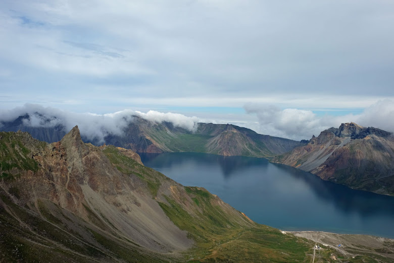
At the top of Paektusan, with Chonji lake below, China on the other side.

It is a relentless ascent, but fortunately the clouds are getting higher as we climb further upwards. In the same effort to improve the tourism in the area, they are constantly working to improve the facilities and sights at the mountain. Slogans too, as it appears. On the side of the mountain it is written "Holy mountain of the revolution" in large letters. Small yellow flowers are clinging to life in the barren scenery of the mountain.

Me and some of the guides on the hike at Paektusan, Mr. Hwang, a local guide, me and Mr. Kim.

Another view of Paektusan with Chonji lake in the caldera.

At the crest of the caldera, we are met with a wonderful view of the mountain and the lake at the bottom of it, Chonji. Considering the low clouds hanging over the mountains earlier, we are exceptionally lucky to be able to witness this view too. The mountainsides running down the caldera is truly colorful, made so by the volcanic soil. Paektusan is an old volcano, with the highest point being the summit of Janggunbong at 2750m. The large crater, about 4km wide, that we see today was created when the volcano erupted in 946 (part of the volcanic debris was actually found in Greenland too). Guarding this side is numerous soldiers. It is far from quiet though, given the loud songs that are played to motivate the workers. It is a little bit surreal. Having walked around the crater a little bit and enjoying the scenery, we then gather to listen to a local guide telling us about the mountain. Only problem is that I can see clouds returning from China to cover the mountain again.

Janggungbong, the highest summit of Paektusan. Not long after this picture was taken, the summit was covered by clouds.

View down towards the tip of the caldera from the path up towards Janggunbong.

I am correct, just before we reach the summit, we and the mountain are covered by clouds. With this low visibility we are not allowed to climb to the highest point. I am tiny bit disappointed, naturally given my curious mind, but fact is that we would not have seen anything from there anyway, and I guess that we would not be allowed up anyway due to the strong winds. Disappointed or not, I am really happy to have seen the beautiful caldera and top of the mountain.

The long staircase leading down to Chonji lake.

A fun fact, the close proximity to China makes it possible for us to receive and send messages on our phones. In North Korea our phones will not work, but here we can get reception from China.

At the bottom of the crater lies Chonji, or Heaven Lake as it translates to. This is the deepest mountain lake in the world, with a maximum depth of 384 metres. From the lip of the caldera you can take a cable car down to the shore of the lake. The other way is to walk down on a very long staircase of stone, which we do. Climbing down, we descend underneath the clouds situated like a lid on top of the mountain. Coming out of the clouds, we can see the cable car, with excited screams when it suddenly swings in the air. By the sound of it, the ride must resemble something from a theme park.

Looking up towards Paektusan from Chonji lake, clouds hanging like a lid over the caldera, a cable car on the way down and a long line of stairs heading up into the clouds and mountain.

Chonji, or Heaven Lake, down at the bottom of the caldera. China on the other side of the lake.

It is a scenic spot, standing and looking out across the lake. I am still fascinated by the color display in the sides of the caldera. On the other side lies China. For South Koreans, that side is the only way for them to visit their sacred mountain. It feels sad in a way. Roger Shepherd has a hope that this hike could be seen as a part of a reunification of Korea. He is walking with what is called the reunification flag, which is white with an undivided Korea in blue without borders.

Two young Korean students at the shores of Chonji.

When we go to find a place for lunch, a group of young students arrive at the lake, filling up their waterbottles as is customary. The staff has been carrying our lunchboxes, sheer luxury. We get eggs, various vegetables including pickles, a sausage, some fish, some chicken, a bundle of tiny whole fish and lots of rice. Roger gets interviewed while we are eating. From above we can still hear excited screems from the people taking a ride in the cable car.

View from the shores of Chonji.

I do not count the steps as we climb up again to the fog and the mountain. At the top, a soldier escorts me across the terminus of the cable car. He is far from the stern faced soldier we would expect to meet, instead he is curious and while asking about me, he is also talking about Paektusan. Then I allow him to take my camera and take a picture of me (I cannot take a picture of him on the other hand).

Roger walking with the Korean reunification flag, blowing in the wind on the way up from Chonji.

With the mountain hidden even more in the clouds it is time to leave. We take the surprising way down. On a track going right next to the funicular. As we descend lower and lower down, the clouds opens up and lets us view more and more of the scenery that was hidden. Then I start to hear the wire used by the funicular begin to move. In the middle of one of the rickety bridges we have to cross, I can see the car coming down from the top. I reach safety in good time, but Paula and Rafael (one of the reporters from AP) just makes it across before it runs past them. I wave to the North Koreans in the funicular and they smiles and waves back at me. It was a fun walk down.

Descent from Paektusan going on a path right next to the funicular.

From the foot of the mountain we will be going to the place where we will be camping for the night. We walk past a couple of locals, most of them starting to laugh when we both tries to greet each other in English or Korean. The low clouds are making the scenery look like something out of Scotland, it resembles a heath, with green-gray undulating hills. A light drizzle is in the air. We pitch our tents down in a wadi, a dry stream bed. The staff has already arrived and pitched their tents and is preparing the dinner for the evening. The staff consists of Mr. Han, the driver, Mr. Kim (Big Kim) and a busdriver.

Narrow escape down the Paektusan funicular, Rafael and Paula looking at the car passing by after just coming off the bridge.

North Koreans greeting me from the passing funicular.

For dinner we get hot noodles with meat, and the sweet, soft, crunchy starbread to go with it. The driver has brought with him some homebrew made of blueberries, which is called duljjuk sul (blueberry wine). The evening is good and a nice end to this first hiking day in North Korea.

Fog on the North Korean heath below Paektusan.

Paektusan is a beautiful mountain, but it is almost only when you stand at the top of it that you truly understand why. It is also a very nice mountain from afar too, of course, but you need to climb it to see the true wonder of it. There are several tour operators that offers guided tours to the mountain, so if you are visiting North Korea and have time, you should be able to do so. The problem is its remote location and the only way to get there as a tourist is to fly to Samjiyon, there are only two flights a week. The mountain is also capricious when it comes to weather, so one cannot expect to arrive in good weather. I felt we were lucky to be able see the mountain given the weather we had today.

Dinner at our campsite below Paektusan. Mr. Hwang, Paula behind, Jo, Mr. Kim and Mr. Kim.

Even though climbing Paektusan was great, I do feel that the more special part of this hike begins tomorrow. As we then will be going hiking in an area few foreigners has been visiting.

My tent at the campsite in a dry riverbed below Paektusan.

<- Pyongyang & SamjiyonSoyeonjibong secret camp ->

popular posts