Wednesday, September 30, 2020

Gudbrandsdalsleden


Gudbrandsdalsleden is the most known of the pilgrim paths in Norway. It begins in Oslo and ends at the tomb of Olav den Hellige in Trondheim or Nidaros. On its way it passes either on the west side (Vestleden) or the east side (Østleden) of Mjøsa, goes through the valley of Gudbrandsdalen, then crossing over the Dovrefjell mountain, before it goes through Trøndelag until it reaches its destination at the migthy Nidarosdomen cathedral. The pilgrim way is about 643km long.

In the autumn of 2020, I did the pilgrimage to Nidaros, walking the Vestleden route from Oslo to Lillehammer, then Gudbrandsdalsleden from there to Trondheim and finally the Østleden route from Lillehammer back to Oslo. Here you will find my tale:

Day   1 (31.08): Sagene - Amtsbrua
Day   2 (01.09): Amtsbrua - Norderhov
Day   3 (02.09): Norderhov - Sløvika
Day   4 (03.09): Sløvika - Høgkorsplassen
Day   5 (04.09): Høgkorsplassen - Kapp
Day   6 (05.09): Kapp - Sveastranda
Day   7 (06.09): Sveastranda - Lillehammer
Day   8 (07.09): Lillehammer - Stalsbergsvea
Day   9 (08.09): Stalsbergsvea - Fåvang
Day 10 (09.09): Fåvang - Sygard Grytting
Day 11 (10.09): Sygard Grytting - Sjåheim
Day 12 (11.09):Sjåheim - Dovreskogen
Day 13 (12.09):Dovreskogen - Furuhauglie
Day 14 (13.09):Furuhauglie - Kongsvoll
Day 15 (14.09):Kongsvoll - Bruvollen
Day 16 (15.09):Bruvollen - Hæverstølen
Day 17 (16.09):Hæverstølen - Stamnan
Day 18 (17.09):Stamnan - Olskastet
Day 19 (18.09):Olskastet - Gumdalen
Day 20 (19.09):Gumdalen - Gaula
Day 21 (20.09):Gaula - Trondheim
Day 22 (21.09):Trondheim / Nidaros
Day 24 (23.09):Brøttum - Rudshøgda
Day 26 (25.09):Domkirkeodden - Tangen
Day 27 (26.09):Tangen - Ljødal
Day 28 (27.09):Ljødal - Dal
Day 29 (28.09):Dal - Arteid
Day 30 (29.09):Arteid - Sagene

Tuesday, September 29, 2020

Gudbrandsdalsleden // day 30 // Arteid - Sagene

Gudbrandsdalsleden, Østleden, day 30.
Distance: 45.2km (953.3km).


Rain outside in the bitter morning hours. Good to see on the clock that it is still too early to crawl out of the sleeping bag when I hear it drum lightly on the roof. Is it a bittersweet morning to wake up to when you know it is the last day of a long hike? Maybe, but I also feel that I am ready to come home.

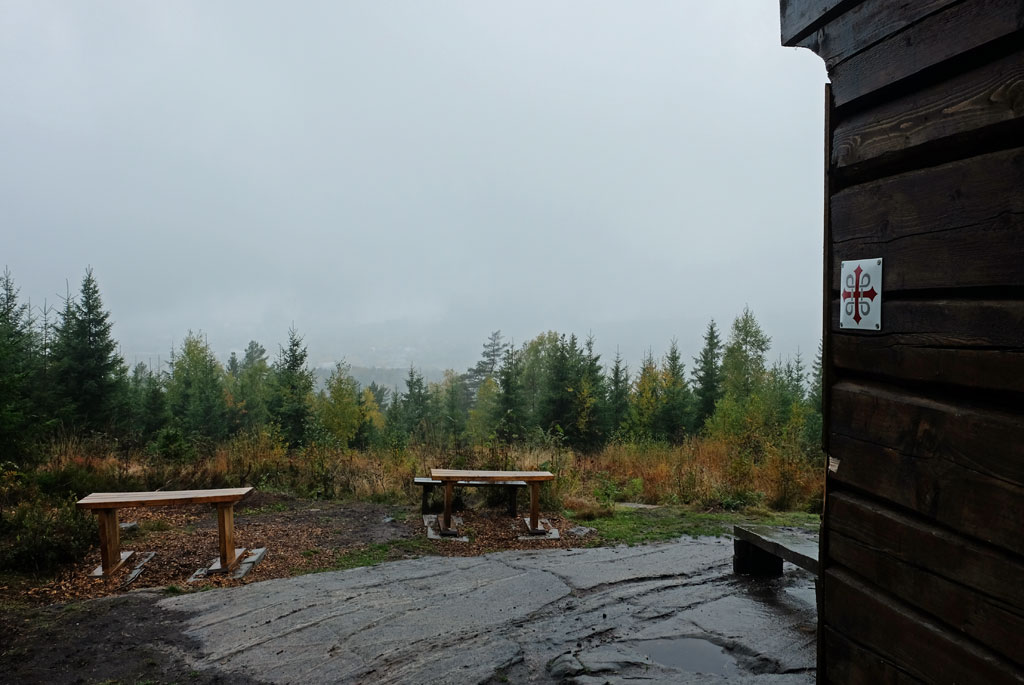
Melancholic fog over the fields from Arteid in the morning.

When I start walking, fog has taken over for the rain. Not much, a melancholy layer that provides its own atmosphere where the trail goes down along a field before it moves into the forest towards Vilbergfjellet.
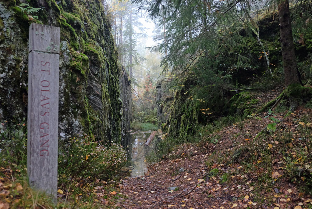
St. Olavs Gang.

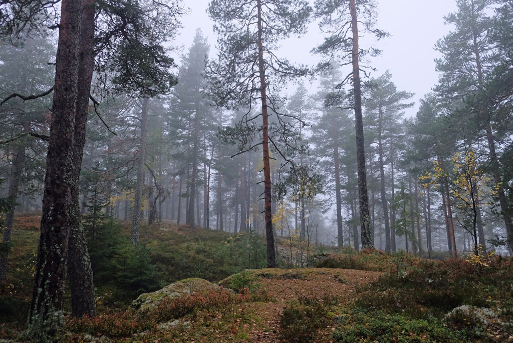
Covered by the thin layer of clouds, I go up into Vilbergfjellet, autumnal colours mixed with green and fog-grey. St. Olavs Gang is a geological gorge that is 200 meters long and 3-4 meters deep. Legend has it that here Olav den Hellige should have sailed so low over the hill that his ship made a depression in it. The route does not go through the gorge, and for those who want to give it a try it will be a wet experience. In the current weather, the place has a somewhat mysterious feel.

Through the misty woods over Vilbergfjellet.

This is the first time I have met a deer lice fly and is an annoyance right away.

Autumn colours in the fog at Lindeberg.

The rest of the walk over the hill is nice, I come out to an even greyer and sadder world, but the autumn colours of the trees and fields make it not as bad as it sounds. Still, it is quickly forgotten when the forest is laid behind me. The walk to Frogner church is not very memorable.

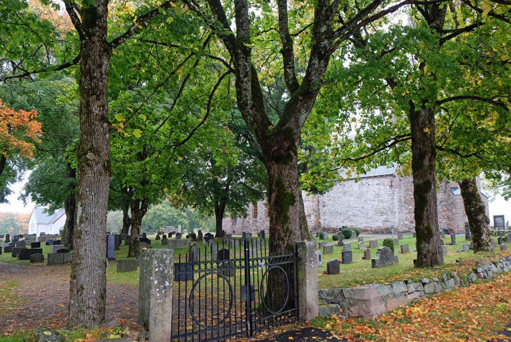
The smaller of the two Frogner churches, this is a medieval brick church from 1180.

Is Frogner church Østleden's answer to Søsterkirkene (‘the Sister Churches’) at Granavollen on Vestleden? Hardly, but there are now two churches here as well. The larger of the two is a wooden church that was built after the previous one burned in 1918. Next to it is the smaller church made of bricks from 1180.

A meandering wet road through a landscape marked by sad weather.

From the churches I cross down between two fields and then a winding and wet road awaits me. The ground is heavy with rain, the asphalt is darker, and the surrounding landscape is heavy. It is a dense greyness that I find myself in, despite that, I am still cheerful at heart. Out of the greyness comes heavy power lines, clouds drift mercilessly through the trees in the surrounding hills, behind me the largest church tower of Frogner church protrudes among yellow trees. The sadness has turned into melancholy.

Frogner church in the background along with autumnal colours that light up the otherwise sad color spectrum.

Oldtidsveien (an ancient road) is followed over Farseggen. The grey weather is hidden from the sides of the trees and shrubs, the walk becomes a little brighter. This is the old road between Skedsmo church and Leirsund, which goes over a narrow clay ridge between two deep ravine valleys. It is unknown how old the road is.

Farseggen.

Skedsmo church is as old as the smaller of the two Frogner churches. At this point I have walked a little over 13km, it is still a long way to go, and the world has not become any less grey during that time.

Skedsmo church.

With Skedsmo-krysset (a large well-known junction) and Olavsgaard in sight, the pilgrim way passes by some houses, and then goes through forests and fields. In the air there is light rain and several more of those annoying deer lice flies. At the Åros bridge there is a sign for Nittedal church, which is the first sign for me that I am now approaching my homecoming.

The pilgrim way in autumnal colours between two fields.

Hellerudsletta is perhaps one of the most notorious stretches along the pilgrim way from Oslo. Here, the heavy transport passes by at high speed, while I slightly discouraged walk on in the colourless world. Fortunately, it is not an extremely long stretch.

Autumn trees out in a field.

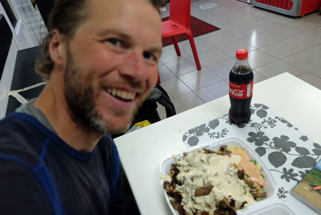
Normally this would have been unthinkable for me, but on a long hike like this it is not a problem to indulge in lots of food. For lunch, I eat a full kebab dinner at Grytelokket, it goes straight down.

The lunch for today, junk food at Hellerudsletta.

The correct route up into Gjelleråsen in the opposite direction is not easy to find. Finding a route up is easy, but not the pilgrim way, but after finding it, I soon find myself in familiar surroundings. It may not be a long walk over Gjelleråsen, but it is nice and is probably the first proper green part of the pilgrim way you get to when you leave Oslo on Østleden.

View, if it can be called that, from the shelter on Gjelleråsen.

I take a detour out to a shelter that provides a good place to rest with a view over Oslo. There is almost no view to get now however, one can just glimpse buildings from the city below.

The upper bell tower in Gjelleråsen, these were used to notify any travelers at the other end that they were on their way, in order to prevent queues. The ancient road over Gjelleråsmarka was steep and narrow, so oncoming travelers in the opposite road would have had problems being able to pass each other.

Along Oldtidsveien you pass several cultural monuments. Among these are some old bell towers, one upstairs and one downstairs, these were used to warn travellers at the other end that they were on their way. This was because the road was too narrow and steep for travellers to pass each other by if they met in the opposite direction. Here it is also marked with some yellow arrows. The journey goes down through Kongedalen. And then the city borders are right at your feet.

The pilgrim path on the ancient road down Kongedalen.

If the hike is not as exciting after crossing into Oslo, there is more positivity to be found in the sky. The layers of clouds are about to loosen up. This is a part of Oslo that I have not been to before, so it is fun that way. The walk through the city alternates between the relatively peaceful and the noisier where the trail goes near the E6 highway.

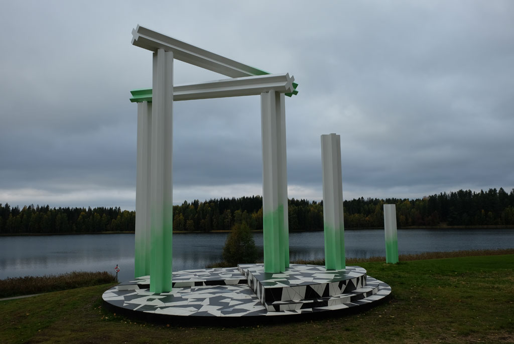
Sculpture in Verdensparken ('the World Park').

Just before Østre Aker church, the sun suddenly breaks through the clouds. It is wonderful and it gives me a feeling of arriving in nice weather. The nice light follows me through Ulven, past the sports halls at Valle, next to Fyrstikktorget and through Kampen. Still, I feel a little that Vestleden through Oslo was calmer and more interesting than Østleden. Anyway, now the goal is so close that I am not much affected by it.

A small piece of farm in Oslo.

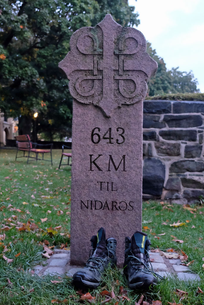
Then I am at the junction where I took off 29 days ago and started on Vestleden on my journey towards Nidaros. Feel a slightly tingling in the body. And then I enter the gate to the Minneparken and the ruins of Hallvard Cathedral. And is again standing in front of 634km to Trondheim. I am back.

Crow in sunset.

The darkness descends calmly when I take the obligatory contemplative break here at the start and end point of my pilgrimage. Ventilate my mind a bit.

Kampen, Oslo.

However, I am not completely finished with the walk, the last part remains. The charm stage home to your own door. It is an abrupt wake-up call to walk through Grønland, here there is little indication that we are in the middle of a pandemic. After being out on a solitary walk for 30 days, it is a transition to be back in a larger crowd again.

At the finish, back to the start. Arrival at Minneparken after completing Østleden from Lillehammer.

I follow the lights up after Akerselva again, roughly reversing the walk down from the first day. Have to take a small detour and go up Kjærlighetsstien again. It is a beautiful moon over Oslo. Someone I talk to tells me that it will be possible to see the northern lights tonight, but to take the trip out of the city for that I have no plans of now.

Great moon over Oslo on the way home.

After a long hike, it is probably in place with a small celebration. I take it right before I get back to my door. Drinks two beers at Sagene Lunch Bar, and I hope I am forgiven for probably not smelling too good.

Sagene church.

Sagene church is lit up in the dark. And then I walk around the corner of my own block. At the end is my door, the door to the end of my pilgrimage from home and up to Nidaros on Vestleden and Gudbrandsdalsleden, and then home again on Østleden.

I go in, closes the door behind me, feels the heat from my own apartment. And then I smile broadly. I am home again.

The shoes have done their part. After 30 days of hiking, I have walked the pilgrim path to Nidaros. Vestleden and Gudbrandsdalsleden from Oslo to Trondheim. Østleden and Gudbrandsdalsleden from Lillehammer and back to Oslo.

<< Arteid // day 29

Monday, September 28, 2020

Gudbrandsdalsleden // day 29 // Dal - Arteid

Gudbrandsdalsleden, Østleden, day 29.
Distance: 40.5km (908.1km).


Now my pilgrimage is undeniably coming to an end, but there are two long days left. The plan today is to go to Arteid and then it is to return to my own door tomorrow. The breakfast at the hotel should provide enough energy to get me far on the day, there was plenty of food.

Oversized holiday chairs outside Leto Arena, plenty of space.

Outside the hotel there are some oversized holiday chairs, I take a seat in one of them before I continue the short way down to another corona-closed hostel, Risebru. Here you will also find an old stone vault bridge, dated 1827 (restored in 1994).

Older road signs at Risebru.

From here you can follow the road uninterrupted, but the trail takes you on a small detour. The weather was grey when I stuck my head out the door of the hotel, but here where the path takes one around a small pond, there is a light of hope above me. A short and peaceful little walk around a pond with ducks happily splashing around in, over an ornamented little bridge, in a light that highlights the colours of the background. Afterwards you climb over a stile and are back on the road not very far from where you left it.

After Risebru, the pilgrim path goes around this small pond.

Going in the opposite direction has presented some problems, but going with a guidebook that is not completely up to date also offers some problems. In my version of the guidebook, I will go up to Sessvollmoen, but in the updated version you will not do it, no matter which way you come from.

The pilgrim way no longer goes here, but I ended up going here anyway as I had not the updated guidebook with me. After Sessvollmoen.

An undulating field landscape.

On the other hand, I am dutiful and follow the instructions, even though there are no waymarkers. Here I am doing great and finds the route, which is no longer the route, but there are still some waymarks that remain. I look over at the fenced military area and walk between fields without knowing if I am on the right path. Finally I am back on the same road as before (again).

At Dagsjøvegen.

A slightly dystopian element on the walk.

Being on a road or not, I am now a little in my own world of thought, so the hard surface passes by quite unnoticed. I find the patterns in the undulating acre next to the road fascinating and then that the pilgrim path takes off from the road just past the same acre shortly afterwards.

The eighteen Arhats in Lien Hoa Dao Trang Buddhist Temple (The Lotus Temple).

After a short walk through a forest, I take the wrong path again. Get to see stone crusher machine in a quarry at close range. Not very scenic, but interesting in a way, maybe more than what the actual route is.

Lien Hoa Dao Trang Buddhist Temple (The Lotus Temple).

Trafficked roads and unattractive walking follow. Until memories begin to fill up mind. Suddenly I am back in another time, back to another place. I was not well enough prepared for this probably, I am outside the Lien Hoa Dao Trang Buddhist Temple (Lotus Temple).

Nordbytjernet.

The surrounding landscape is not the same. I do not wear a straw hat on my head, white vest or staff. I am not on Shikoku, but the memories from there are popping up now. I just have to go in and ask if I am allowed to look around. This is a Buddhist temple according to Vietnamese tradition, and thus not quite like the ones I visited at Shikoku. In the area you can see statues of the four great heavenly kings (Tứ Đại Thiên Vương), the eighteen Arhats (Mười Tám La Hán) and not least the bodhisattva Địa Tạng (Kṣitigarbha). The eighteen Arhats in a row remind me of the Gohyaku-Rakan statues in Japan (they are related).

Broken Thrones by Camilla Løw, Nordbytjernet.

With the heart sutra in mind, I continue. Eventually I come to Nordbytjernet, after a somewhat elusive walk there, where it is peaceful. Perhaps even more peaceful than it is during normal times, with less air traffic from Gardermoen right next door. Looking out over the water you will find the Broken Thrones artwork by Camilla Løw, inspired by European 19th century pavilions that meet modern materials.

The sword at Raknehaugen.

The route follows around the water, takes a short walk through a forest and after a bit of walking along a road I come down to Raknehaugen. This is the largest burial mound in Northern Europe, with a height of 15 meters. If you walk around it, you have walked 77 meters (you should not go up on it). The burial mound dates from the migration period between the years 400 and 600. A sword meets me at the foot of the mound, the runic inscription found on the sword (a sculpture and replica, not a real sword) should indicate: ‘This is the king's sword’.

Raknehaugen.

In Jessheim I put the pilgrimage on hold for a short break. Afterwards, I am out in the woods again. It is a pleasant walk over to the place with the somewhat ironic name Høyfjellet (translates to ‘High Mountain’), but it is not further exciting. Between the fields and the farms afterwards there is a nice light.

Herredshuset, Jessheim.

And then my ability to orientate does a short circuit and I turn right instead of left where the pilgrim way comes down to Randbygrenda. Had I continued and then turned left at the next intersection, I would have been able to return to the pilgrim way again at Ullensaker church.

Through the woods towards Høyfjellet.

On the other hand, it would mean that I would have missed Den Wingerske Kongevegen. A cosy stroll alongside fields. In a nice light I walk towards Romeriksdomen which protrudes from the trees in front of me. The real name is Ullensaker church, which is a fairly new church from 1958 and is the fourth church that was built here since the first saw the light of day in the 13th century.

Waymarker on a tree with its shadow.

Here I am heading in the wrong direction at Randbygrenden.

The pilgrim path has passed through a golf course before (Atlungstad), the waymarking through Miklagard, however, is not as good in the opposite direction here. The sole means of visiting Kløfta is to get to the store to buy the last dinner and breakfast for the hike.

Den Wingerske Kongevei.

The darkness begins to descend as I approach Arteid, suddenly the red colour off the waymarker-poles has turned yellow and dazed I take the wrong path (why have it changed colour to yellow here?). At Arteid Vestre, a loft has been turned into a place for the pilgrims, that is at least red.

Ullensaker church.

Inside the loft, on the second floor, the pilgrims have got their pleasant little cave. There is even a massage chair here, and an antique-looking oven that can still be used. Should there be anything to complain about, it is that the shower and toilet are located some distance away in the yard (in retrospect, this should now have been improved).

Walking on Den Wingerske Kongevei.

The evening comes and dinner is prepared. And what matters most now is to relax for the very last day of the pilgrimage. Which also will be the longest day of them all. When the night has arrived tomorrow I will be at home in my own home, that feels weirder now than on my other long walks. Then I have always had a journey home where the feet have not been the primary means of travel.

The pilgrim hostel at Arteid Vestre.

Relaxing here inside the pilgrim hostel at Arteid is no problem. Outside, a light drizzle has begun.

Inside the loft for pilgrims at Arteid.

<< Dal // day 28Sagene // day 30 >>

Sunday, September 27, 2020

Gudbrandsdalsleden // day 28 // Ljødal - Dal

Gudbrandsdalsleden, Østleden, day 28.
Distance: 23.1km (867.6km).


The floor inside the shelter is made of stone, so when I went to bed for the night, I used the wooden bench instead, a better surface for my inflatable sleeping mat. The table made sure I would not fall down during the night.

Inside the shelter at Ljødalsvegen.

Yesterday I decided to walk to the Best Western Leto Arena Hotel today, a little luxury after the splashing through the woods yesterday. Since both the weather outside is better than expected when I look out the door and that the clothes have actually dried better than expected, I consider the alternatives.

On the way towards Eidsvoll from Ljødal.

After cleaning out after me and closing the door behind me, I leave the tiny hut that gave me shelter after hours of rain yesterday. The pilgrimage continues towards Eidsvoll, which is the nearest town in the direction I go, but it is a few kilometres there.

A moose with a hat.

The route further alternates between paths and gravel roads, past residential houses and small farms, both messy and tidy. Not always as easy to find when you go backwards in a way. Finally I reach a road with its hard asphalt, which I will follow on and off for a while.

Haug pilegrimsrast.

Autumn trees, Tønsaker farm.

Except that I of course go wrong and do not find out until I suddenly see the pilgrim path reappears from the side right next to a moose with a hat on.

Art, Eidsvoll.

Den knelende soldat (The kneeling soldier), Eidsvoll.

Before taking the road down to Eidsvoll, I come to Haug Pilgrimsrast (pilgrim hostel). Which looks nice. It could have been fun to spend the night in the greenhouse, or the glass cage, but it might get very hot in the middle of summer. Hard to say if I could have reached here or not yesterday. On the fields afterwards, it seems that there is archery training ground path.

Inside Eidsvoll kirke.

Eidsvoll kirke.

Eidsvoll is completely quiet and calm, as it often is in Norwegian small towns and villages on a Sunday. Not one place to get a coffee, except at the Narvesen kiosk at the train station (opted for a place in the centre, so casually walked past the gas stations before).

On the road after Eidsvoll church towards Eidsvoll Verk.

The church, on the other hand, is open, I am back in the fold of confirmations. Talk a bit with someone who works at the rectory, they also provide accommodation that is closed this year. He also checks the opening hours for Eidsvollbygningen. I have obviously taken my time, considering not going that far today, now I get a little time pressure on me.

At Dønnum the picnic tables are lying upside down.

Overgrown path after Dønnum.

I do not like having a time pressure, but must endure it, probably just my own fault. A bit of walking on paved and gravel roads before the interesting thing begins. At Dønnum, and the youth institution there, the trail disappears into something that may resemble a ravine landscape (the path was otherwise unclear here, only a windswept patch revealed that it had been changed a bit). By the way, it was fun to see all the picnic tables (with ceilings) lying upside down just before I start on the path down. What has gone wrong here?

Surely enough, here goes the pilgrim path. Crossing over a field, on rainy days it could be very muddy.

Lines in the acre, at Venjar.

The path takes you down, before it crosses a small river on a bridge, then it starts steeply up again. Passing a memory tree, planted by Marie Wenger Bergem the day before she emigrated to North Dakota in the United States. That was in 1921. Up in the light again, an acre stands in front of the pilgrims, no matter which end you come from. After the rain showers yesterday, there is a great danger that the ground is muddy, but it is better than expected. Do I cross straight over where I am supposed to go? No.

Remains of a factory or power station (Mago) in Andelva.

It gets nicer when the pilgrim path takes me down to Andelva. Here you walk in quiet and peaceful surroundings right next to the river. On the other hand, trees and farmhouses are reflected in the water. This is a type of walk that has not been so much of on the pilgrim route otherwise.

Walking next to Andelva.

Lovely and nice walk around a small u-turn in Andelva.

I manage to reach the last guided tour of Eidsvollbygningen, I also manage to get a coffee in the café before. Eidsvollbygningen is where the national constitution of Norway was created and signed. ‘Enig og tro til Dovre faller’, which could be translated to something like ‘Agreed upon and faithful until Dovre falls’, now it has been some days since I went over Dovre. Although I prefer to go alone and study things when I am at museums and the like, it is a nice tour of the origins of the constitution. I like the fake windows on the outside, for those who have discovered them.

Eidsvollbygningen.

It is not very exciting after Eidsvollbygningen. After Eidsvoll Verk and the train station, the route goes through a residential area in Råholt. Although, I am not sure. There are signs that the trail has been changed to follow the main road instead. Old waymarks, on the other hand, are still standing where I go. The church in Råholt dates from 1888.

A stately room in Eidsvollbygningen.

The national hall or assembly hall in Eidsvollbygningen.

Arrives at Leto sports hall. At this point I have capitulated, the hotel here will be the endpoint of my walk today. The place has a bit of a Rudshøgda feel to it, but I do not find out if there is anything more unusual about it. I will not leave the building upon arrival.

Råholt church.

I was comfortable all the way on the hike today, warm and with relatively dry clothes, but it still felt incredibly good to get a shower. Yesterday may still be felt a bit. It is very quiet in the hotel, but it suits me quite well. The dinner I order is very good, better than I expected. Relaxing with a beer in the foyer. Chewing on the fact that now it is only two days until I am home again, two long days on the other hand.

Dinner at the Leto sports hall hotel.

<< Ljødal // day 27Arteid // day 29 >>

popular posts