Saturday, October 25, 2014

Baekdu Daegan


Baekdudaegan (the great white main ridge) is a 1700km long mountain ridge that runs along the entire length of the Korean peninsula. The unbroken mountain ridge is the watershed of Korea and it never crosses water. The ridge begins at Korea's most sacred mountain, Baekdusan (2750m), which is situated at the border between China and North-Korea and ends at Cheonwangbong in the Jirisan-mountains in South-Korea. The mountain ridge is a strong symbol of the identity and nationalism for the people of Korea, it is the spirtual backbone. The 735km long section of the ridge in South-Korea also hosts a long distance trail, called Baekdudaegan, starting at Cheonwangbong and ending at Jinburyeong. In the fall of 2014 I travelled to South-Korea to walk the mighty Baekdudaegan trail, this is my story from it.

Prologue  i (03.09):Jungsanri
Prologue ii (04.09):Jungsanri - Cheonwangbong
Day   1 (04.09):Cheonwangbong - Seseok
Day   2 (05.09):Seseok - Nogodan
Day   3 (06.09):Nogodan - Gogiri
Day   4 (07.09):Gogiri - Maeyori
Day   5 (08.09):Maeyori - Bokseongijae
Day   6 (09.09):Bokseongijae - Baegunsan
Day   7 (10.09):Baegunsan - Yuksipryeong
Day   8 (11.09):Yuksipryeong - Satgatgoljae
Day   9 (12.09):Satgatgoljae - Bbaejae
Day 10 (13.09):Bbaejae - Samdobong
Day 13 (16.09):Jakjeomjae - Keunjae
Day 14 (17.09):Keunjae - Jigijae
Day 15 (18.09):Jigijae - Hwaryeongjae
Day 16 (19.09):Hwaryeongjae - Piatjae
Day 17 (20.09):Piatjae - Neuljae
Day 18 (21.09):Neuljae - Beorimigijae
Day 19 (22.09):Beorimigijae - Eunti
Day 20 (23.09):Eunti - Ihwaryeong
Day 21 (24.09):Ihwaryeong - Mungyeongeup
Day 22 (25.09):Mungyeongeup
Day 23 (26.09):Mungyeongeup - Haneuljae
Day 24 (27.09):Haneuljae - Ansaengdal
Day 25 (28.09):Ansaengdal - Jeosuryeong
Day 26 (29.09):Jeosuryeong - Jukryeong
Day 27 (30.09):Jukryeong - Gochiryeong
Day 28 (01.10):Gochiryeong - Buseoksa
Day 29 (02.10):Buseoksa
Day 30 (03.10):Buseoksa - Doraegijae
Day 31 (04.10):Doraegijae - Hwabangjae
Day 32 (05.10):Hwabangjae - Pijae
Day 33 (06.10):Pijae - Daetjae
Day 34 (07.10):Daetjae - Samhwadong
Day 38 (11.10):Daegwanryeong - Noinbong
Day 39 (12.10):Noinbong - Guryongryeong
Day 40 (13.10):Myeonggaeri
Day 45 (18.10):Misiryeong - Jinburyeong
Epilogue (19.10):Jinburyeong

Sunday, October 19, 2014

Baekdu Daegan // epilogue // Jinburyeong

It has now almost become a habit to rise up at the crack of dawn on the trail, so it is no surprise that I wake up by myself early in the morning this day as well. Since I am finished with the hike, it feels extra good to be able to just close my eyes again and continue sleeping. My body is light of expectation when I finally rises up from the bed, to a day without hiking. Outside, there is a thin haze being illuminated by the sun. I eat breakfast, bibimbap, in one of the restaurants below the pension, morning rice and morning haze.

Jinburyeong, upon arrival from Baekdudaegan (picture taken the day before).

Jinburyeong.

There is not much left to do here, but I have one thing I would like to do before I leave Jinburyeong and Baekdudaegan for now. With my backpack packed and ready, I walk down to the small area with the stele; I want to do another small celebration. There it is teeming with people now, a bus stands parked nearby and a large group is embarking on a large-scale preparation of food and drinks. They seems to be hikers that have finished their hike on the Baekdudaegan, they have probably hiked it in stages as most Koreans do.

At the finishing line by the stele in Jinburyeong. A hard and beautiful walk through South-Korea on the mighty Baekdudaegan is at its end.

I have made my own homemade hiking ribbon that I hang up among the other ribbons where the trail ends. At the same time, a new group of hikers are coming down from the ridge, where each hiker receives a flower and are being escorted down to the stele going through a gauntlet of cheering Koreans. For fun, I get in line after the arrived hikers and walk down myself; I also receive a flower and is being cheered at. It feels like a more worthy and deserved ending of the hike than the quiet arrival yesterday.

A group gives me a flower and are cheering at me at the end of the trail.

Then it is time for departure. After having walked and looked at the East Sea from the ridge for a long time, I have only one specific wish, and that is to get down to see the ocean. I have therefore decided that I will go to Sokcho, where I afterwards will travel to Gimcheon to visit Mr. Cho Byeongsam and his wife. The bus arrives, I take a last look up towards the ridge that I have come down from, before I enter the bus. It is with a strange feeling that I drive with the bus down from the ridge that I have spent the last 45 days on. It has been an adventure of the rare, a hard adventure, but one I certainly would not have missed. With me, I carry a part of the lifeforce that flows down from the spiritual backbone of South-Korea.

The little area that marks the end of the trail. A group are celebrating their finishing of the trail. By the banner, it looks like they started their hike on the 7th. April 2013.

In Sokcho, I go straight down to the sea and sit down to just look out towards the horizon, while the waves slowly rolls towards the beach.


<- Jinburyeong

Saturday, October 18, 2014

Baekdu Daegan // day 45 // Misiryeong - Jinburyeong

Baekdudaegan day 45.
Distance: 14.1km (761.4km), time spent: 9:46 (383:59).
Altitude (start / end / highest): 800m / 500m / 1244m.
Weather: Nice and clear, cold in the beginning, then warmer.


It is still in the wee hours of the morning when I rise up from the hard bed. As used to rise up early and then walk to the next place as I am, it feels kind of unreal to think of that this is probably the last day on my walk. That tomorrow will the line of days where I am moving towards a given target be broken, that I actually am at the goal. My breakfast is several sweet pastries that I bought yesterday evening. Sokcho is still in the dark when I leave its outskirts in a taxi up towards the bygone hyugeso at Misiryeong. We drive past the huge Del Pina resort that I could sit and look down upon the previous night, illuminated by a countless number of lights.

Sunrise over the East Sea and Sokcho from a small plain above Misiryeong.

At Misiryeong there are now several cars parked, with people sleeping inside them. It is dark, cold and gusty outside; a cup of coffee is warming me while I am waiting for enough light to start walking. The path from here is clear, even though it is closed. Just above the pass, there is a small plain with a good view down the valley towards Sokcho. The sun has begun to rise up from the haze over the East Sea, and emits a reddish glow on the sky. From here, Ulsanbawi is seen as a narrow silhouette. Further up above me there are more than one blitz flashing, I am not alone on the trail. It is a worthy start of a last day.

Morning splendour over Baekdudaegan above Misiryeong and below Sangbong. Ulsanbawi and Daecheonbong are clearly visible.

The road over the pass is left further and further behind me as I go upwards, I can see the huge fields of boulders that I passed over yesterday and Daecheonbong is still standing vigilant above the dinosaur spine. The trail involves quite a lot of scrambling and climbing. There are clear signs of military activity in the area, with various bulwarks and trenches of varying quality. Remains of radio wire that lies like tripwire across the path. And is there not a North-Korean reconnaissance patrol I can see sneaking through the forest further down? Probably not, but there has been rumours of such visits in the area.

View from Sangbong towards Sinseonbong.

At the summit of Sangbong (1244m), it was supposed to be an egg-shaped doltap, in the guidebook depicted with snow inside the crevices on the cairn, but there were no traces of it there now. For a small moment, I wonder if I have gone too far, that the subsidiary summit I had passed actually was Sangbong, but it could not be correct. I can hear the boys ahead of me on the path shout from Sinseonbong; the Koreans do has a habit of yelling from the summits. The trail continues in the same style towards that peak, with scrambling and boulders as obstacles, but also going more through woods.

The summit of Sinseonbong (1214m) is not situated directly on the trail, eventually you can say that the trail does not cross directly over the summit. The name of the peak signifies a place for departure of spirits; it is a fitting moment standing on the summit on the day that I probably departs from the spiritual backbone of Korea. The plaque with the name and altitude of the peak has partly fallen apart. The view is great beneath the blue sky; there is a small veil of haze lying over the landscape below towards the sea.

More great views, from the summit of Sinseonbong in the direction of Ulsanbawi and Daecheonbong.

From Sinseonbong the trail makes its way down, past several military relics, some fenced in by barbed wire. At Daeganryeong (ridge pass) I leave Seoraksan National Park, and this closed section of the trail. It is a small pass down in the forest; small windshields are created of rocks amongst the trees, signposts and information boards. A group of hikers are sitting and having lunch, soju, makgeolli and food in large quantities. I take a short break at the pass while I listen to the satisfied mumbling of the Koreans.

Descent to Daeganryeong from Sinseonbong, in the horizon you can see the last peak on the Baekdudaegan before Jinburyeong.

I decide to eat lunch on a more quiet spot further up, at a rocky outcrop with views back towards Sinseonbong and Sangbong. It feels almost a little bit sad to think about that this is probably the last time here that I prepare my usual mix of noodles, rice and ham, but to be honest, I am a little bit tired of it. Outside the national park, the forest gets more prominent again, but it is a pleasant path through it. I meet Dong Chon with two friends that are congratulating me of having done the trail. Now, I am not quite finish with the walk yet, but it is not many kilometres left now. Satisfied with myself, I shortly after tumble out of the clean air and fall flat on my face, I am tired.

I arrive at a summit carrying for me an unknown name, and from there I can look down towards Nunmulgogae and the abandoned ski resort there, knowing that further beyond the crest lies Jinburyeong. A group of walkers enjoys the weather at the summit and offers me makgeolli. My body aches, but I cannot do anything but smile. The trail dips beneath the forest again before it takes me up to the last summit on the Baekdudaegan (the trail, not the ridge, which continues further on over several summits on its way to Baekdusan), Masanbong (1051m). There are voices all around me now.

At Daeganryeong, a signpost and a group of walkers having lunch.

Standing above some trees below, I can see the clock tower of the ski resort, there time is standing still. On the other side of the valley lies the last ridge before the demilitarized zone and North-Korea. It feels strange to be standing here, when I start to walk down from the peak I will at the same time walk down from Baekdudaegan. It is a little distance down for someone with sore feet. It is as if the knowledge that I am soon finished, makes me more aware of the signals from the body, it knows that it will get some rest soon. If I had been talking loud while I am walking down, you would have heard a series of grunts for each time I put down my foot. I now feel on the body how the others with blisters walking the Camino felt it (I do not have any blisters though).

View from Masanbong. Below lies Nunmulgogae and the abandoned alpine resort. In the background, the last peaks before the demilitarized zone between North- and South-Korea.

The trail goes past the decayed and deserted place, as curious as I am; I have to go in amongst the decay. Large and empty buildings where the vegetation now grows free, a ghost town. The feeling of being watched while I walk between the buildings. Voices that disappears in the air. The hands of the clock displays different times depending on which side you look at. There is however still beauty in decay, the trees here has beautiful red leaves. It is a strange ending of a long walk.

Walking between the empty and deserted buildings in Alps Ski Resort, a ghost town so to speak, the hands on the clock tower has stopped on different times depending on which side you look at. The vegetation has begun to take over.

I also visit the small place next to it, Nunmulgogae, which now seems like a very sleepy place, with some dilapidated houses there as well. From here, it is less noteworthy; the trail passes by some quiet farms. I make a huge smile next to a sign telling me that it is 1km left to Jinburyeong, 1km. An adventure is nearing its end. I come out on a road, where on a small lawn are put several plaques and tablets, supposedly by more wealthy Koreans to commemorate their hike on the Baekdudaegan.

Then, through the trees can I see Jinburyeong and the large stele that marks the end of the trail. I come out of the trees past the last of the fluttering ribbons. Walks over to the large stele, places a hand on the rock. My legs are aching, my feet are sore, my knees are knackered and I have never felt as thin as I do now, but I have made it. 45 days I have spent on walking from Cheonwangbong on the spiritual backbone of Korea. It is not a huge fanfare upon my arrival at Jinburyeong, just an uninterested gardener that does not care much. The occasion calls for a small victory toast of soju, I have now officially finished the trail.

One kilometre left, a somewhat unreal moment.

Unofficially, I have a very small hope of, but not particularly faith in, to get to do a fitting epilogue. In the guidebook Roger Shepherd and Andrew Douch goes up to the summit of Hyangnobong inside the military zone at the border of the DMZ. The peak lies at 1269m about 2km south of the 4km wide demilitarized zone. They are escorted up, and there were limits to where they could go and what they could do. The only possibility to find out if I am allowed is to ask at the army camp at Jinburyeong, which I do. I ask nicely, but those posted there does not have the authority to allow it, something I had not expected either. So, after that the walk is both officially and unofficially finished. I cross the street for a celebratory beer at a restaurant and send a message back home that I have made it (which promptly causes me to receive a call from home). Later, I found out that Shepherd and Douch got permissions from higher up (no, not that high up), something not anyone can expect.
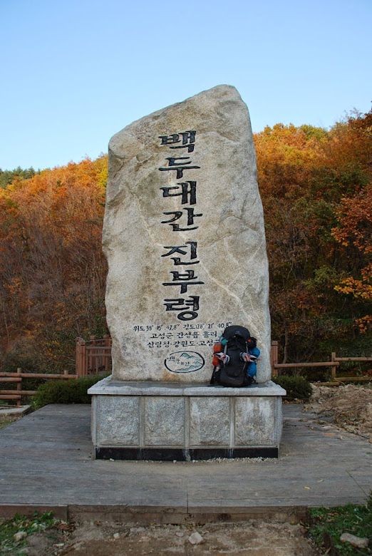
Jinburyeong, my backpack placed next to the large stele that marks the end of the Baekdudaegan trail. 45 days after I left Cheonwangbong in Jirisan, I have completed the trail. Satisfied and tired.

Jinburyeong consists of a small street with shops and restaurants, a museum, several memorials, aforementioned Baekdudaegan stele and an army camp. I find myself a place to stay at a pension just above the small main street, which is run by a friendly host, almost as a small apartment. In the evening, I eat dinner and drink some beers in one of the restaurants below the pension. The rest of evening is spent celebrating a little bit in my room. I know that I am done, but it feels weird, you do not understand it completely until the next day, when you no longer put on your backpack and continue walking (and still often not, then as well). That being said, my body is probably quite happy by it. Satisfied, it gets dark over the end of the trail, Baekdudaegan.

A journey is over, another begins.

<- MisiryeongJinburyeong ->

Friday, October 17, 2014

Baekdu Daegan // day 44 // Gongryong Neungseon - Misiryeong

Baekdudaegan day 44.
Distance: 12.8km (747.3km), time spent: 10:46 (374:13).
Altitude (start / end / highest): 1200m / 800m / 1381m.
Weather: Very nice, but strong wind.


Wake up from the windy night and feel the cold chill of the morning. It has been the coldest night on the walk so far, and the wind has been at it during the whole night. Still, I have slept relatively warm and good, even though I woke up a couple of times when it was at its worst. Wind can make a lot of noise. I choose to walk a little bit before I will eat breakfast; it is chilly down between the spines of the dinosaur. First, however, I would get to see the sunrise, so I climb on top of a cliff nearby to see the first rays of the sun appear over the edge. There are silhouettes of people at the top of Sinseondae. Charged by the sunrays, I lift up my backpack and continue walking.

Sunrise from the dinosaur spine.

The trail fortunately does not go straight over all the rocky formations and spires, which would have demanded climbing equipment and had been a huge challenge, but winds itself around, up and sometimes over them. Ropes and small railings you could let either hang for decoration on the steepest parts or if you wish, use them as aid to get up or down. It is a spectacular walk where the view is nothing less than majestic. If the trail further into the DMZ had been just as fantastic as this one, I almost could have continued walking on it without taking care of the chances of being shot or stepping on a mine. So great is it, though you should not go around and encourage people to go there.

Ulsanbawi, an infamous and huge rock outside of Sokcho.

When the sun and the walking has warmed me enough, I sit down below a cliff and prepare breakfast, which becomes a sight for many a hiker passing by. Even though it is still early in the day, I meet many hikers, it is clear that Seoraksan is one of the most popular national parks here. It seems that almost of the national parks has some kind of a main artery going through them; this must be the one in Seoraksan. Some hikers says straight out that this is their favourite mountain in South-Korea, I shall not argue against them. There are a lot of smiling, and tired, faces out walking. Jeong is something that is never forgotten, a walker rummages through his backpack to give me a pack of noodles.

After coming up to a small platform between two spires, I just have to let go of my backpack and climb on top of one of the spires. It is a path that requires some concentration, but up at the top of the spire the reward is great. A good base to see how cool the spine of the dinosaur really is when you are standing on the midst of it. Me and another has to play daredevil and balances out on a thin ledge with a fall down on all sides except the one we went out on. Daecheonbong is watching intently from above.

Up at the top of a spire on Gongryong Neungseon there is tough view down towards the valley below with Sokcho and the East Sea in the background.

The dinosaur throws me off at Madeungryeong Samgeori, where there is a path going down in the direction of Sokcho, Biseondae and the temples by that entrance to Seoraksan. From one of the temples in the valley below, Gyejoam, there is a short way up to the characteristic edge or huge boulder of Ulsanbawi, which has been in my line of sight since yesterday. Ulsanbawi is an infamous rocky formation that juts up from the landscape like a knife's edge, and is offering a thin, somewhat demanding and spectacular walk across. It is tempting to go down to see all of what the valley below has to offer, but my journey continues further into the forbidden section after Madeungryeong, 300 meters further up.

From the top of the spire, I can look down upon other hikers that are climbing on the spine of the dinosaur.

The landscape changes character a little after Madeungryeong, a kind of smaller version of the tremendous ridge I have passed, something that makes me give it the name of Dinosaur Jr. Spine. The biggest difference is though that the path is worse, more overgrown and there are many loose stones on it that makes it a little bit difficult walking here. It does not take away the experience of a nice hike. The wind that calmed down after the sunrise this morning has now begun to blow with heavy force again. So much that I on the top of a cliff are not able to stand upright, but has to sit down to take a picture. Balancing out on the ledge that I did earlier, would now have been really dangerous.

Balancing out on the tip of a ledge, in the background Daecheonbong and the part of Gongryong Neungseon I have walked over.

The cliffwalk, unlike the ridgewalk, is over when I set off down towards Jeohangryeong. The descent crosses over a large field consisting of large boulders, it is heavy work, but doable. In very bad weather, this part of the route would have been difficult. Jeohangryeong is now a very quiet pass with several crossing paths, but these are now mostly completely overgrown. From the pass, you climb steep up towards Hwangcheolbong (1381m), on the way I pass a 'fake' summit with a homemade sign on that makes me slightly confused.

From the 'fake' summit (1368m), I can follow the course of the dinosaur jr. spine and the dinosaur spine towards Daecheonbong that is towering in the background. In the horizon to the north lies the DMZ and the mountains in North-Korea, I can see the summit of Hyangnobong and the abandoned ski resort at Nunmulgogae above Jinburyeong. There has been some hollow rumbles in the air at times today, I look a little bit unsure towards the north sometimes. That Hwangcheolbong lies covered up by the vegetation, together with the 'fake' summit and that the path here is not marked, are making me at first take the wrong path at the proper summit and walks for a short time in an unknown direction.

By Madeungryeong Samgeori, in the background the spire that I climbed on top of.

With the map and the compass consulted, I am back on the right track again. Down towards Misiryeong I encounter yet another accumulation of obstacles that provides more wear for my aching joints and sore feet. The trail passes over several huge fields of large boulders. The wind is blowing hard and keeping the balance on the rocks are difficult and time consuming. Stubbornly and slowly, I move downwards, on lookout for the best path through the boulders. A fall here could cause serious trouble. In the end, I step in under the safety of the branches after having left the last of the rocky fields.

From the real summit of Madeungryeong, the dinosaur spine in its entirety below Daecheonbong.

The sun is on the wane when I am getting close to Misiryeong, through the trees I can see another surveillance camera on the path. Unsure whether the camera is in use or not, I resort to the bush again, which means more hurting bashing through scrub and thicket. I locate a path that leads me down to the road just below the pass, with a tall fence between the road and me. More hurting bashing through scrub before I get to the end of the fence. I found of all things a golf ball while I was pushing myself through the bushes, later on, I found out that I had lost my bottle of soda that I used as an additional water bottle inside the bush. I was not happy with that; do not like to leave behind things in the nature.

On the way down the rocky fields towards Misiryeong. On the other side of the valley, you can see the summit of Sangbong, in the background the mountains in the demilitarized zone between South- and North-Korea.

I was somewhat anxious to end up in the dark again on the way down, but I got down before that time. In the guidebook, I could read about what the hyugeso at the pass had to offer, but also that they were unsure of how long it would survive since the paths on both sides of the pass are closed. They were completely right about how long the hyugeso would survive, the former wooden building is definitely closed and in visible decay, almost as a ghost house. Outside there is a large parking lot with a great view down towards Sokcho and the East Sea. As a compensation for what the restaurant had to offer, there are some vending machines on the parking lot selling hot and cold drinks, which I gladly make use of.

The closed and decaying hyugeso at Misiryeong.

While the wind is blowing cold around me, I am unsure of what to do. Stay at the pass or leave the ridge for a place. Sokcho far down next to the sea is tempting, but it is a long way there. Of course, I forget that whatever happens, Baekdudaegan will provide. A bus consisting of old people on a trip is stopping at the pass in the dusk. I nicely ask the driver if he can call a taxi for me, which turned out to be not so easy. Instead, it ends up with that I get to ride on the bus down to Sokcho. In the outskirts of the city, the bus drives past some motels and they are kindly letting me off next to one of them.

In a restaurant in the outskirts of Sokcho, the walls are covered by drawings and greetings from former guests.

I am looking forward to another night in a bed. After showered my now quite tired body, I walk in the dark through the little neighbourhood until I find a restaurant. No 'opse' here, I get served meat on the grill (bulkogi). The walls in the restaurant are covered by greetings and drawings from former guests. Another guest looks up, smiles, greets me and says that we met on the dinosaur spine earlier on the day, funny. On the way back to the motel, I buy myself some Friday snacks. Potato chips, maekchu (beer) and chocolate. Which is greedily consumed in the motel room while I am relaxing, my knees are really tired. It feels unreal to think that tomorrow is probably the last day of my walk. A beautiful day.

<- Gongryong NeungseonJinburyeong ->
Thursday, October 16, 2014

Baekdu Daegan // day 43 // Hangyeryeong - Gongryong Neungseon

Baekdudaegan day 43.
Distance: 13.1km (734.5km), time spent: 9:34 (363:27).
Altitude (start / end / highest): 900m / 1200m / 1708m.
Weather: Heavy rain and fog, then heavy blue sky.


The night is not yet over when I get up; the sleepy hours before the day comes to life has almost started to become a habit now. It feels almost a little bit sad when I close the door after me and step out into the quiet dark to find a taxi that can drive me back up to Hangyeryeong. I would very much have liked to say goodbye to the elderly couple that ran the place, if nothing else to say thanks for my stay. It is bloody dark up towards Hangyeryeong, and only the headlights from the car makes me see anything at all, where the taxi winds its way up the meandering road towards the pass. The day should turn out to be just as winding by character as the road. More than a dark landscape, I did not see from my visit in the Oseak gorge.

In a wagon outside Hangyeryeong, a street vendor sits and sell food, drinks and equipment in the morning.

Hangyeryeong is just as wrapped in darkness. Since I do not wish to go before it starts to become light, I am pretty much obliged to wait. Outside the hyugeso, which has not opened yet, there is a street vendor with a small tent outside that provides nice cover for the cold wind. There, I am sitting together with some other walkers who also are waiting to go, while they are eating hot noodles. When the day dawns, it is without any signs of the sun, it is greyish and hints of rain in the air.

The clouds are temporarily withdrawing back over the mountains, on the way up from Hangyeryong for the second time.

The trailhead is next to the entrance of the restaurant, on a concrete staircase that takes you up to a closed building of some kind. It is a steep incline, but since I am located in a national park, it is facilitated for walkers with a series of staircases. It does not take long time before I feel the first raindrops. A loud thunderclap resonates from the sky. I continue walking for some time and then the rain just gets worse and worse, before I stop completely and makes a turnaround. I cannot explain to myself why I am giving up, it just stops, tired and not motivated to walk in the rain and not knowing where I am going to spend the night. Rain and wind are tearing through Seoraksan's rocky formations. Dejected I explain that I am giving up to a couple, who just ends up smiling.

View down towards Naeseorak, or inner Seoraksan, the rocky formations also receive a glimpse of the sun.

I am almost back down at Hangyeryeong again, when the layers of clouds suddenly tears apart and blue sky pushes itself through. Not to believe, so I make another turnaround. Both time and strength tossed away. Going upwards, the trail passes between trees that looks like ghost trees, where the leaves has left the branches and lies forgotten on the ground. Well-made natural staircases of stone clings to the surface upwards. However, the weather has not made a full turnaround, further up it is closing in on the mountains again, but the rain is fortunately absent.

The trail passes through grey trees that looks like a ghost wood from the fairy tales.

Ruptured hills of rock are reaching up from beneath the clouds, from the ridge I can look down upon what is called Naeseorak or inner Seorak. Seoraksan is about 400 000km² big and is split into three sections, Oeseorak (outer), Namseorak (south) and aforementioned Naeseorak. Before, I have walked through Namseorak over Jeombongsan for instance, and Baekdudaegan forms a natural dividing line between the outer and the inner section. Oeseorak is the most popular section and is situated closer to the coast and Sokcho. I overtake the smiling couple, which now becomes the laughing couple. They share a sausage and an apple with me by a nice viewing point, where we can look over towards Jeombongsan that is now hidden in the clouds, and down towards where the road meanders its way up to Hangyeryeong.

View down towards a valley beneath a grey and desolate sky, Jeombongsan hidden in the clouds in the background and you can see the road that meanders its way up towards Hangyeryeong.

The fog has the upper hand again over Jungcheongbong, and the wind has increased in strength. There are no views to be had from the summit (1664m), only a land of fog. When I am getting closer to Jungcheong Shelter in the gale, a man is coming hollering behind me and stop me to save the rain coat of my backpack, which is about to loosen and disappear into the clouds of Seoraksan. We walk together to the cabin, where we just can see the summit of Daecheonbong under the clouds. It was here that I initially had planned to walk to today; but when I called to reserve a place, there were none left. It turned out to be no places left on any of the cabins in the area. The plans was changed, I then thought of going to Madeungryeong instead, now my plans has to be changed again, I will probably not reach there before it gets dark. And that I do not wish.

On the way down from Jungcheonbong, view towards Jungcheong Shelter and Daecheonbong.

After a small break in shelter for the wind inside the cabin, Jang Kung Bey and I are continuing up towards Daecheonbong. And now it is as someone has gone around and painted over the grey colour of the sky with blue paint, the strong wind are blowing away the clouds. Seoraksan has opened up its arms for me; I am awestruck and happy that I choose to turn around for the second time. At the summit (1708m), there are quite a lot of people, and the view from the next to tallest mountain on the mainland of South-Korea is excellent. And most prominent in the line of sight is the dinosaur spine (Gongryong Neungseon), with Ulsanbawi behind. I can see the trail that twists and turns around the characteristic rocky formations that the spine has its name from.

Magnificent view from the summit of Daecheonbong, which is the highest mountain on the mainland of South-Korea. Below you can see Gongryong Neungseon (the dinosaur spine); in the background, the famous rock of Ulsanbawi and Sokcho.

Jang Kung Bey is only out for a day hike, and continues further on the path leading east that goes down from the mountain. There will be no sunset or sunrise from the summit of Daecheonbong for me, since I have to move on, so I spend some more time at the summit to enjoy the moment before setting course down towards the Huiungak cabin. At some places, I pass small patches of snow. The Huiungak Shelter is a smaller, calmer and more atmospheric cabin than Jungcheon, and reminds me a little of the Yeonhacheon Shelter that I passed on my second day of the walk. Which is somewhat strange to think of. A small creek runs past the cabin, where I eat my lunch.

Sokcho and the East Sea as seen from Daecheonbong.

I have decided to look for a place to camp as soon as I walked some distance away from the cabin, even though I know it is not allowed, the problem is that the trail now is venturing up into the spine of the dinosaur and I believe it is not many straight surfaces there. The trail goes on its way up towards the cliffs on built up paths like paved roads in the nature. The first time I am located at the top of the spine, I am standing at Sinseondae, which means a lookout and a spiritual platform for Taoist immortal spirits. I do not want to be on the back of this dinosaur when it starts to move, it is mighty.

Gongryong Neungseon or the dinosaur spine. Pointed rocky formations pushing upwards, and the trail passes by in between them.

Then a perfect spot to pitch the tent is coming up, it has a nice flat surface, view towards Sokcho and the sea, and it is in shelter for the wind. Though I do not pitch my tent right away, it is something I will wait to later to do. Instead, I spend my time relaxing and climbing around on the dinosaur, before I find me a good place to enjoy the sunset. I can however envy those who get to see it from the summit of Daecheongbong a little, even though it is very nice from where I sit. After the sun has left, I walk back and pitch my tent.

Sunset from the dinosaur spine.

With the changing weather, I have almost been able to see Seoraksan in all sorts of nuances, and that I am extremely satisfied with. I prepare and eat dinner with an evening view of the lights from Sokcho and the boats capturing squid on the East Sea. The wind is now coming from another direction, and it blows fresher. I am a little bit cold when I crawl into my little cave. Wrapped in a warm sleeping bag, with a little toast of soju to warm me on, I can do nothing but to thank for a fantastic day.

<- HangyeryeongMisiryeong ->

Wednesday, October 15, 2014

Baekdu Daegan // day 42 // Jochimryeong - Hangyeryeong

Baekdudaegan day 42.
Distance: 24.0km (721.4km), time spent: 11:55 (353:53).
Altitude (start / end / highest): 770m / 900m / 1424m.
Weather: Sun and clear blue sky.


I am at the final days of my walk, days there was something mystical and exciting about when I read about them in the guidebook. The cause of it may be that these are the days that seems so far away when you are in the beginning of a journey, those that lies as something mystical in the horizon and the future. Now that I am here, the start at the summit of Cheonwangbong feels a long time ago. There are hoarfrost on the ground outside Olleh house beneath Jochimryeong in the morning. Halfway through October, the nights are getting cold.

Sunrise over the mountains in the east, from a viewing platform just above Jochimryeong.

Before I go, there is a knock on the door and one member of the family running the place are coming with breakfast for me, three bags of warm rice that contains ham and eggs, together with a bag of sweet potatoes. I choose anyway to save them for lunch, to save time later being the reason for it, and eat a pack of noodles instead. It is still dark outside when I walk back up to Jochimryeong again; my breath makes tiny wisps of smoke in the air. It is gradually getting brighter. The sky has a reddish hue when it creaks beneath my shoes up the pathway from Jochimryeong. I still a bit why I chose to walk down from the pass yesterday, I actually liked it at the pass. That being said, in hindsight, I do not regret it.

Blue sky, mountains in the horizon, a bird in the sky, a beautiful day in the mountains of South-Korea.

A short distance after setting off, I come to a viewing platform, which appears just in time to show the sun's approach over the mountains in the east. A great light and a red ball that almost disappears behind a cloud when it is above the mountains, my audience over, but the sunrise is following me through the trees upwards. A faded sign marks a favoured place for taking photos, there is a little layer of clouds lying and swaying calmly back and forth in the valley below, the East Sea baths in the sun. The trail changes direction after the sign, both vertical and horizontal, towards west and beneath the embrace of the forest again.

Sangbu Dam, a water reservoir, is visible through the trees with Jeombongsan in the background. Signposts along the trail stated that you should not go down to the reservoir.

There is a mountain in the horizon that has my complete attention today, and that is Jeombongsan, I already notice that I am beginning to look after the mountain through the branches in the woods. When I peek through the trees, I can also see Sangbu Dam nearby with its accompanying windmills. And for a good time the path goes so deep down in the forest that I do not see the mountain, hidden behind the trees or another ridge. Just as before Danmokryeong, where a fine flowing creek is running below the trail. The sound of water trickling downwards are always uplifting.

The leaves lies heavily on the ground. A walk through the forest on the way to Jeombongsan and Hangyeryeong.

At Danmokryeong, I cross the border of Seoraksan National Park, the last national park on my journey through South-Korea. I have already done it so many times now, that I think very little over that I am moving into a closed section again. Even though I do wonder what will happen and what I will do if I am caught. I am not alone in doing it; the ribbons hanging along the path bear witness to that. Now when I do this, I do my best to tread carefully in the nature.

View from Jeombongsan, Mangdaeamsan just below and in the background pointing sharply to the sky, Daecheonbong.

Jeombongsan is getting closer and closer. Up towards the mountain, I can look over to the very heart of Seoraksan, where rock formations extends itself pulsating towards the sky. An army helicopter flies over, hopefully not in pursuit of me. The last part of the climb up to the summit (1424m) is steep, but not as hard as I had feared. It would be a pure lie to say that my body is not aching a little now; the walk has taken its toll. In the guidebook, there is a picture of the summit area covered in snow. Despite the hoarfrost on the ground in the morning, it was probably hoarfrost here on the peak as well, there is little reminiscent of that now. The sun warms the mountain.

In a contest in the 21st century, Jeombongsan was voted the most beautiful mountain in South-Korea. And with an unbroken view in 360 degrees, it is probably difficult to disagree, even though it is probably the mountain and not the view that made it receive most of the votes. Beneath the summit in the direction of Hangyeryeong, the mountainside almost looks like a savannah, though of a more alpine appearance. The most beautiful mountain demands a break.

The summit area of Jeombongsan, sometime voted the most beautiful mountain in South-Korea. In the background above the signpost, you can see Sangbu Dam.

A lunch break is taken just before Mangdaeamsan (1236m), where the bags of rice, ham and eggs comes into its own. Just the thought that I have been on the peak I am looking up at, are getting me in a good mood now. The wind is blowing well at the moment; the autumn sways from side to side. I need coffee, a double dose of Korean coffee (kopi), so up with my stove. I am getting close to Hangyeryeong now, with Daecheonbong towering in the background. The area around Daecheonbong is famous for its jagged and torn rocks; going downward the path is giving me a preview.

From the summit, the landscape reminded me of a savannah, with the green trees as lonely trees among the barren earth.

For now, cliffs and rocky formations are breaking up around me as well, which I have to climb across and around. I can look down towards the Osaek gorge (the five colours valley), which apparently is a beautiful valley like the Mureung gorge. Navigating down are however starting to turn a little bit difficult. In the midst of all the cool scrambling that I like, I struggle a little bit finding the correct way. The guidebook did warn me about this part. At a point, I take a wrong turn down, and have to spend some time going back up to the trail again. The view is atoning for the entire struggle, it is an enjoyment all the way down, I can look down towards Hangyeryeong and dream of all that exists of food and drinks there.

Jeombongsan.

At a point, I get standing and wondering for a while, before I find out that the trail is continuing visible around an outcrop. I am glad it is still light, but the clock is beginning to tick a little, I do not want to go down here in the dark. After the last challenge it gets better, which consisted of a quite awkward descent where I have some problems finding good placements for my legs and feet. My backpack is in the way and I do not dare dropping it down, in case it should fall over and disappear further down. The first time I did not feel completely confident with the scrambling on the walk.

Before I arrive at Hangyeryeong, I have to twist myself around some barbed wire to get down to a road. I walk tired up to the doors of the restaurant. It is many people here; I have not met anyone on my journey from Jochimryeong. While it is darkening outside, I sit inside with a potato pancake (gamjajeon) and a cold beer, and wandering where I am going to spend the night. It is not enough space on the pass for my tent, and the hyugeso does not operate as a minbak. The people at the place are trying to help, but their English is not good enough.

View down towards Hangyeryeong and the hyugeso there (in the middle of the picture) from one of the cliffs on the way down.

I end up taking a taxi, which is convenient standing outside, to the little village at the entrance to the Osaek gorge, Osaekri. The Osaek gorge is a popular tourist destination, which means that it will be a couple of restaurants and hotels here. Not a hotel for me though, the taxi driver drives me to a minbak run by an amiable older couple, who unfortunately does not speak English, but are very helpful. My body aches quite a lot now, and I have to laugh when I see how thin I have become when I look in the mirror. Something I try to atone for by tussle up in the dark to a restaurant, it is quiet and very few people outside. The restaurant has grilled boar on the menu, which is served with a lot of vegetables, rice and soup. I have to grill the meat myself, of course.

A preview of what Seoraksan National Park has to offer, on the way down to Hangyeryeong. Rocky formations that breaks loose from the vegetation and extends towards the sky.

The end of the walk today reminded me a lot of the walk down to Neuljae through Gaegumeongbawi, with Beorimigijae also fresh in memory. Luckily, I now came down before it got dark. Today, I have stood on the summit of what has been voted the most beautiful mountain in South-Korea, and tomorrow the very heart of Seoraksan is awaiting me.

<- JochimryeongGongryong Neungseon ->

Tuesday, October 14, 2014

Baekdu Daegan // day 41 // Guryongryeong - Jochimryeong

Baekdudaegan day 41.
Distance: 20.6km (697.4km), time spent: 9:16 (341:58).
Altitude (start / end / highest): 1031m / 770m / 1204m.
Weather: Clouds, then nice, but cold.


Quiet in the morning, the sound of rain is just a memory again. I notices quietly in my mind that I did not have the urge to continue walking yesterday, as I usually have on my rest days. That urge I do have now however. I eat breakfast while I am looking at an American TV series (NCSI). When I am packed and ready there comes a knock on the door, the host is ready to drive me back up to Guryongryeong, under the colourful trees.

From Guryongryeong Baekdudaegan is continuing up a wooden staircase.

Quiet up at the pass as well, the tables and chairs from the marked are standing empty next to the stele. Mr. Sang-Su Nam has now arrived either, which is a pity; I would have wanted to say goodbye. When the host at the minbak says goodbye, he presents me with a bag with food. A look inside the bag reveals that it contains a cabbage, two onions, and a small bag with candy, one apple, one beetroot, two tangerines and two bags of dry wipes. You get speechless by lesser gifts than this.

The vegetation are sparse and it becomes more apparent that you are walking at the top of a ridge, with a good path to walk on. On the way to Galjeongokbong.

The irony is not lost on me when I begin today's stage, which starts with a steep staircase straight up the hill, when I discover that there is a water source flowing just next to it. The sun is hidden behind some clouds in the beginning of the day; there were small glimpses up towards its domain at Guryongryeong. The continuing ridge reminds me a lot of the previous stage, it is the autumn that characterizes the trail now, but even though it is not a flat terrain the ascents and descents does not feel that hard. The path is good to walk on as well, even though the cloudburst of yesterday has left some traps behind. I do slip some times.

Up towards Galjeongokbong there is a tree blocking the path; it is customary in Korea not to move the tree off the path.

Galjeongokbong (1204m) is the highest point between Guryongryeong and Jochimryeong, whereupon the summit someone has made a makeshift stele: two casual stones with the name of the summit jotted down in Hangeul on them. And some slightly rotten wooden benches, still wet after yesterday, benches like these should mark the rest of the path today. It is also some kind of custom in South-Korea that you shall not change the natural surroundings in the mountains, therefore you shall not move any trees or rocks even though they are blocking the path. Something that explains why no one has done anything with a tree lying across the path on the way up to the summit, it looked like it has been lying there for a while.

The best view of the day came after having left Galjeongokbong. The compass needle is pointing towards the north, in the direction of Jeombongsan and Daecheongbong.

The trail is bringing me steadily northwards, from before I have already been able to see into the mountains of North-Korea. A cliché would be to say that I now are getting closer to the heart of darkness. It is still so that I often have a feeling of having walked towards the heart of the trail, deep inside the area or country that I am walking in, when I am in the final days of a walk. And the trail is undeniably going towards the border of the dark country to the north. There is otherwise very little that is dark here I am going now, it is a pleasant walk.

The gift from Healing House that I spent the night in, dry wipes, cabbage, tangerines, apple, sweets, beetroot and onions.

It is a pleasant walk between small picnic areas in the forest. At Wangseunggol Anbu the worn benches and stubs creates a corral, with a large space within the circle. I never cease to be amazed over the tombs I come to up here in the mountains; I pass another beautiful tomb on the path, what a place to have as a final resting place. Next picnic area is Yeongarigol Samteo and here I sit down to have lunch. Samteo means water source, but is in reality located somewhere below the path next to a trickling creek. With the blue background, it becomes a colour play in the forest.

Yeongarigol Samteo. A colour play in the nature next to a small water source.

I should have eaten the lunch down by the spring, but smart as I was, I left the backpack back up at the ridge. The gift from the hosts at the minbak meant that I could expand my usual noodle dish with additional goodies. I feel that I am having a sumptuous meal here under the peaceful sky of trees. In addition to the noodles, I gorge upon an apple, chocolate, some of the candy I got, pieces of the cake I bought, soju, coffee and a bottle of lemon soda (Chilsing Cider).

Ready to prepare my standard issued noodle dish with ham above Yeongarigol Samteo, with the gift from the people at the minbak in Myeonggaeri, I could supplement the dish with additional vegetables.

Baramburi Samgeori is the last picnic area before Jochimryeong, as in the previous places there is also water nearby. I however think that Roger Shepherd and Andrew Douch has confused this rest area with Yeongarigol Samteo, both in a picture in the guidebook and where the information board about how the forest is a green dam is located. That board is located here at Baramburi Samgeori and not at Yeongarigol Samteo, but it does not matter much. The reason of the description of the forest as a green dam lies in that it contains rainwater and slowly streams that water downwards.

A pathway of wood leads you over the trees just before Jochimryeong. Clear blue sky over the ridge.

Just before Jochimryeong, the path goes over a cool wooden pathway, which gives me a small feeling of walking on the treetops. It is also just before Jochimryeong that I encounter the first other people since I left Guryongryeong. The last metres goes between small trenches and steles before I reach the big megalithic stone that marks that I am finished for the day. Next to the monument, the Baekdudaegan continues from here up another pathway. Jochimryeong is the halfway mark of the whole Baekdudaegan through Korea.

Jochimryeong, with the megalithic monument and the wooden pathway that leads you further into the realm of Baekdudaegan.

A road goes through the pass in a tunnel; it is a little bit of a distance down to the road. I follow the road downwards, where there are buildings and farms spread around the road. A little haphazardly, I ask if there is an available room at a place, outside there was a sign, but I did not recognize any of the characters for minbak. It turns out to be a stroke of luck, they do operate as a minbak and they have an available room. In the evening, they invite me at a barbecue in the garden, inside a small outhouse. I think I am doing a bad job hiding that I enjoy and need meat, so they are barbecuing a lot of food. I do repeat myself when it comes to praising the Koreans, but I still have yet to meet some that are not nice and friendly.

In Olleh House below Jochimryeong, I was invited to a barbecue in the evening, in an outhouse outside the place I stay at.

The place I am staying at is called Olleh House. Olleh is some kind of tree, but is also the name of a Korean telecommunication company (olleh is as we know hello backwards). I can definitely not complain about this day either.

<- MyeonggaeriHangyeryeong ->

popular posts