
Distance: 10.8km (214.6km), time spent: 6:21.
Weather: Overcast, some rain and fog in the afternoon.
I wake up to a stage on Der Traumpfad that is not so long in terms of distance, only 10km, but should more than make up for it in terms of necessary climbing given by the description of the route. The plan is to walk to the Tuxer Joch Haus, but that hut is famous for its policy of demanding a deposit when booking, which rules out that option for me. I have no means to make a deposit now and has to rely on a bed being available when I show up (and in truth, I do not like to book ahead either). A shorter day might also be a good option when the weather for the day are uncertain, the forecast is for a thunderstorm.

Information board outside Lizumer Hütte displaying which areas where a military exercise will be held today, all but one area has a flashing red light, my path goes straight through one, but the path is not blinking. I should be fine.

Old military paraphernalia, an old cannon stands rusting below Kalkwandspitze.
Lunch is included with the breakfast at the Lizumer Hütte, the bread is of the same heavy sort from before, but that is a small price to pay for such a great hospitality. Looking up at the sky after leaving the cabin, reveals a lot lighter sky than the forecast suggests, patches of blue are interspersed between the clouds. Outside the hut there is a signpost with a map of the surrounding areas. Red led lights indicates which of the areas that there will be conducted a military exercise in. The area I will be walking goes straight through one of these red blinking areas (actually all but one area are flashing red), but I have been assured that the exercise will not start until I should be well outside of the area.
Martina at the start of the steep ascent to the Geierjoch pass.
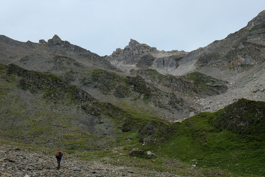
The trail is following the bottom of the valley, before it will start the climb up to the Geierjoch. Towering above me on each side are the summits of Tarntaler Köpfe (2757m), Lizumer Reckner (2886m), Naviser Reckner (2824m), Kalkwand (2826m), Junsjoch (2484m) and Pluderling (2778m), rising up from a mix of green and grey scenery. Next to the path are old military relics, a rusty cannon stands ominously pointing its turret towards the hikers passing by.

View down the Wattental and towards the Lizumer Hütte.

Army chopper doing a reconnaissance of some sort of the area, probably as a part of a military exercise or preparation for one.
Josef had as expected started earlier than me. He opts out of the breakfasts at the cabins and instead insist on walking out earlier to find a place to prepare his own breakfast. An idea that resonates heavily by me, but as I had decided not to bring my tent, I had also not brought with me my cooking equipment. I find him sitting a little bit above the path, enjoying a peaceful morning surrounded by mountains. This would be his last day on the trail.

Junssee from Geierjoch, with Gefrorene-Wand-Spitzen and Olperer at the back.
Ascending, the scenery gets rocky and grey. A path comes in from the left and I become certain that I have taken the wrong route from the hut, but there really is not much that separates the route I had taken and the sort of proper route. Only the surface to walk on, I surmise, the views would be the same. If you follow in my steps on this trail, see that you find the actual route that follows a footpath after Lizumer Hütte and not the gravel track.

Josef sitting at the small stool at the top of Geier.

At the summit of Geier with the vulture statue.
Climbing is steady up towards the Geierjoch pass. Since I left the hut, the sky has become more grey and less blue, as the ground has become more grey and less green. A small shelter of some kind is visible above to my right, but I believe it to be some kind of a military installation. Then loud whirring noises are heard, echoing closer to my location. And then a military chopper comes flying close over my head, taking turns to cross over the pass up front of me. It does several rounds in the valley, hovering close over the small shelter I had seen at some time, confirming my suspicion. I only regret not being higher up when the helicopter flew low over the Geierjoch pass, which would make for a great picture. Eventually the sounds recedes.

Descent from Geierjoch, Junssee below.
The views back down the Wattental valley had been wonderful all the climb up, but it comes short of the view on the other side of the Geierjoch pass (at 2743m). Reflecting the sky lies the Junssee below like a huge eye in the ground, which is a glacial bowl all clad in grey. Behind lies the Gschützspizsattel with the dominating peaks of the Gefrorene-Wand-Spitzen and Olperer towering behind that again. Der Traumpfad can be seen like a clear line winding itself towards the Gschützspizsattel pass, through grey background at first, then green, before back through a grey background. I had forgotten to brush my teeth at the Lizumer Hütte in the morning, this spot offers a far better view while doing that.

Ants....Josef, Michael and Sophia descending from Geierjoch.
Above the pass lies the summit of Geier (2857m), the climb up is relatively easy, but rewarding. Geier translates to vulture and accordingly there is a metal vulture statue at the summit. Wonderfully quirky there is also a small stool at the top too, if a break is needed. Josef arrives a little bit later, just as I was about to go down again. He had wanted to climb the nearby Naviser Reckner too, and I had been toying with the same idea, but we both discards the idea as it turns out. Our paths diverge after here, from the Junssee lake below, he will go down to Hintertux and then Mayrhofen.

Narrow ridgewalk between Geierjoch and Gschützspizsattel.

A view back towards Geier, another interesting descent in terms of how it looks afterwards.
From Geierjoch, the trail heads down towards Junssee (but not all the way down to the lake) on a faint path between loose stones, fairly steep in some parts. In fog, some has warned against taking this route. I go down to the lake, watching Josef and some others descending through the scree from below, they look like tiny ants in a huge field of stones.

The rocky ascent to the Gschützspizsattel pass.
After Junssee, the trail goes first at the top of a minor ridge with steep views down the valley below. Leaving the ridge, the path goes steadily down with the wall of the Geier becoming progressively more massive. Dieter and Karin are slowly negotiating their way across the landscape and steep sections on the way. Clouds are starting to roll in over the Geierjoch. Up to the Gschützspizsattel (2657m) the path is back to an increasingly steeper and stonier surface. The sight from the pass are magnificent, offering the best views of the beforementioned massif of Gefrorene-Wand-Spitzen, Olperer and Hintertux Glacier so far, but the peaks are now having trouble getting clear of the clouds. This is the spot for lunch, no doubt.

View from the Gschützspizsattel pass, Gefrorene-Wand-Spitzen and Olperer besieged by clouds.
Also revealed at the pass, is the steep path I have to descent. The bottom seems so far away all down there. At first going just below the summit of Wandspitze (2614m), then in zig-zags down the mountainside, but on a good path and surface to walk on. Tiny dots moving upwards and tiny dots moving downwards. Marmots are sounding their warning sounds, and I see some scurrying away from the path.

Winding descent from Gschützspizsattel with a mighty backdrop.
I had briefly talked to Michael and Sophia earlier, they had stayed at both the Glungezer and Lizumer huts and at the bottom of the Weitental after having climbed all the way down, I get to talk to them more properly. We walk the rest of the way to the Tuxer Joch Haus together and I enjoy their company. Rain is hitting us on the final approach to the cabin. Tuxer Joch Haus looks like a partially old building, with a modern winter garden in front of it. Thankfully, I have no problem getting a bed for myself.

Path with views of the towering Zillertal Alps.

Michael and Sophia descending.
As the rain settles in, it feels good to sit underneath the glass roof of the winter garden overlooking the dominance of the Zillertal Alps across the valley (despite carrying the name Hintertux Glacier, it is in the Zillertal). The others I met earlier are now at least one day ahead of me, maybe even two. I spend the evening together with Martina, Lucas, Michael, Sophia and Enrique.

A waterfall seen at the bottom after the climb, marked as Wssfall on my map (?).

In Weitental, looking back at the winding descent that we came down upon.
During the afternoon and evening, clouds drifts in from the valley below. I would have expected it to come from above, but the onslaught is rising up from below, engulfing the cabin in fog. At one point there is nothing but whiteness to see outside the windows. I frequently takes walks outside. For dinner I have dessert, kaiserschmarrn, which I call a pancake, to which Sophia greatly objects against.

Tuxer Joch Haus in the afternoon, clouds rising up from the depths.
Another wonderful hike today, maybe even better than yesterday, with Junssee the big culprit in making the difference. Only drawback was that it was kind of short, I probably could have reached the next shelter on the trail, Friesenberghaus (and maybe even the Olpererhütte), but that would have meant negotiating the Friesenbergscharte in rain and fog. Now I am here at the Tuxer Joch Haus, but the evening was nice with good company, so who am I to complain. Olpererhütte tomorrow, their website says there are no beds available, but that is a problem then, not now.

Good company at Tuxer Joch Haus, Sophia, Michael, Martina, Lucas, me and Enrique.
<< Wattentaler Lizum // day 9Riepenkar // day 11 >>


No comments:
Post a Comment