Distance: 22.9km (430.3km), time spent: 6:50.
Weather: Overcast, some sun, some rain.
A late start today, I have to buy provisions for the upcoming last days of the walk. As to where I will go, I do not know. The Forest View Inn in Byrness was fully booked and it appeared that there were no spaces left for tents there either. Which for me, either means staying at the campsite in Cottonshopeburnfoot just before Byrness, or venturing some further up into the Cheviots to find a place to camp there. The infamous time again.

The Village Bakery in Bellingham.
Breakfast and provisioning done, I am ready to go again. In my backpack I now carry with me a new selection of easy cooking food, alongside some chocolate and candy for energy (and if anything should go wrong, I still have the Kendal Mint Cake). And to my great joy, my camera has returned to the living again, a good and warm night did it good.

The road to Blakelaw Farm, The Pennine Way goes into the field to the upper left of the farm towards the cluster of trees seen at the top of the hill above.
I wonder how the Hareshaw Linn now flows over the cliffs as I walk past the turnoff to the waterfall, the weather is more favorable in terms of walking, but not in favor of a frothing spectacle. Blue is the color of the sky, although I can see clouds approaching. The Pennine Way will today be back to its sparse landscape with only a few scattered farms to be seen, but first I have to cope with the hard surface of the road out of Bellingham and up to the first farm, Blakelaw Farm. The path goes straight through the farmyard, where a large group of dogs comes running at me. Fortunately they are friendly and just runs playfully around me before the farmer calls them away.

A signpost beyond Blakelaw, with Bellingham below.
Leaving the farm, The Pennine Way throws me out on a large field with ill-defined paths. From the field, I can look down upon Bellingham and beyond the moorland I walked over yesterday in the rain. Directly below me, I can see the trees hiding the valley containing Hareshaw Linn and Hareshaw Burn. More gates, more wooden posts to show the way and more open land. I get to the junction where there is an alternative route cutting more straight towards the farm of Hareshaw House. The alternative is really not an alternative and I stay on the vague main path. The path is at its most visible when it is wet.

A Pennine Way signpost that has seen better days.
Hareshaw Farm is actually the last settlement that I will get to until close to Byrness at Cottonshopeburnfoot. Just past the farm there is a ruined farm building and afterwards a peregrine falcon circles above my head. Rising in the horizon is another bleak moorland. The Pennine Way crosses a quiet road and then heads up into the heathery slopes of Deer Play, but the deers must be playing somewhere else at the moment.

A fence to a remote area.
This is the best part of the walk so far on this day, with the path winding up into the moors. Most of the vegetation around is heather, all coppery-dark-brownish in color. Above, the sky is thickening with clouds, but they do not appear to contain any rain. And behind me I can see Gil and Sid coming closer with every step, I guess my mood of walking today is of a leisurely one. Or maybe I am preparing myself for the inevitable fact that I will reach the end of the trail in a few days, prolonging the walk.

The path to Deer Play, through brownish heather.
On a blustery day, I believe this could be a hard days walk. That said, a lot of the Pennine Way could be that on such days. There are no shelter from strong winds up here and you will be bearing the full front of it. It is not blustery today, but there is some wind to be counted for, it is a refreshing walk. Sid is catching up with me and we are walking together a little while, before his speed gets the better of me. Gil is still behind me, which looks like the walking pattern of those two, with Sid pushing ahead and then wait for Gil to catch up.

Colors and shade on the hills of the Pennine Way.
Ahead in the distance I can probably see The Cheviots. I pass over Whitley Pike with its small cairns and signposts, the terrain onward is more undulating. We catch up on the three older people that I also saw at Greenhead. At a fence where the path crosses a tiny road, I sit down for lunch together with Sid and Gil.

Sid pushing ahead towards Deer Play.
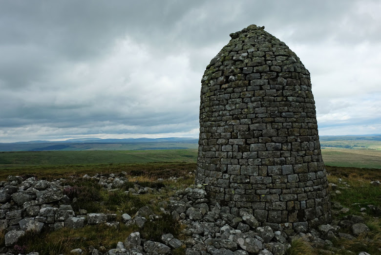
Above the road lies Padon Hill, but the Pennine Way does not cross over the actual summit, it can be seen from the path to the right. And what I see leaves me but no choice than to walk up to it. Of course, it is just my usual curiosity in action. Standing on the summit is a solid cairn, referred to as a pepperpot cairn by Cicerone (or more closely Paddy Dillon), built in the 1920s. The name given is Padon Hill, but it got its name after Alexander Peden. To avoid being persecuted in the 17th century, the Scottish Covenanter preached in remote areas and the legend regarding this hill is that worshippers was required to bring one stone with them to build a cairn. That old cairn is now rebuilt as the one standing stout here with view of the Cheviots.

View of The Cheviots in the distance.
Descending from the pepperpot cairn I arrive at what is described in the guidebook as possibly the worst stretch of walking on the whole of Pennine Way. I am preparing myself for a hard slog up the hill on a path in deep mud, but apart from the trees having fallen across the path, the climb is uneventful. It was actually wetter at the bottom before the climb.

The pepperpot cairn at Padon Hill.
Then the first signs of rain arrives when I am at the top of the hill, not lasting very long. The Pennine Way path turns into a well-defined track of a different color than the vegetation around, kind of resembling the yellow brick road of earlier, only narrower. I think I was supposed to be walking in the woods of north now, but I am only walking on the edge of the forest, with a view of the Cheviots on the other.

The path actually goes under the trees.
The next view of the Pennine Way is a sad one, as the trail enters a part of the woods where heavy forestry has been at play. It looks like a wasteland. A landscape that would not be out of order in games such as Stalker or Fallout, or similar movies, like The Road. The world I am looking over is grey, with a razed ground. In the distance are grey clouds ladden with rain moving over the landscape. I just wait to hear the sounds of falling trees nearby, there are several of them lying next to the path.

Looking back towards Padon Hill.
From the wasteland, the track heads into a proper forest. The feeling here is quite different. Everything is arranged and sorted, looking planted in line, no trees at random (almost). The long and winding road through it. On this section I had completely forgotten about the guidebook warning about the Pennine Way leaving the forest track and heading into the bush next to it on an overgrown and disappearing path, so I follow the waymarks and find myself in the midst of wildly growing vegetation. The three other Pennine Wayfarers also took the path, but we are all soon making our ways back to the forest track. As the guidebook informed me that most people did.

The winding path on Brownrigg Head.
The other hikers are from Australia. A long way from home and after travelling around in Europe, they are here in England for the Pennine Way. We walk together after our escape from the bush, stopping now and then for taking on and off our rain gear. The weather is slightly schizophrenic.

Wasteland.
Byrness and the Forest View Inn is the usual last stop before the hikers tackle the 45km to Kirk Yetholm through the Northumberland National Park. The Forest View Inn also offer a pick-up service for hikers not wanting to do the whole walk in one day and/or does not have the equipment to camp out. The Australians are going there. No place for me there, although I wonder if it is all due to a misunderstanding. When we walk past Cottonshopeburnfoot, I say farewell to the fellow wayfarers and head over to check out the campsite.

Disappearing Pennine Way.
As I have written earlier, I am not overly fond of campsites, I feel confined in them. Then again, the two previous ones that I stayed on earlier on the walk was not bad. The Squirrel Woods campsite was good as I felt it was for hikers, the other one in Hardraw was primary good because I was almost the only person there. This one looks like the usual campsite, but they do have some tiny wooden cabins. The price to stay in one of those however, is 40 quid, which is way too much. The best thing would probably be to push on and look for a campsite in the hills above Byrness, but I am too content to continue, I go for a space for my tent for 8 quid. Cottonshopeburnfoot is by the way the longest placename on The Pennine Way.

The forest track through Redesdale Forest.
Good thing is, the area for the hikers tents are in a flat field just outside the campsite with all its mobile and immobile campervans. Bad thing is the abundance of midges here too. Second good thing is, Sid and Gil are at the same campsite. I had believed they also was going to the Forest View Inn. They have booked one of the wooden cabins, or pods as the manager called them. What they got for the cash was a floor, roof over their head, heating and electrical sockets. The shower at the campsite is like a sauna.

Walking with the Australian Pennine Wayfarers next to the River Rede.
I spend the evening together with Sid and Gil, who are really good company. Sid is from Chester and Gil from Liverpool. I had not brought any coffee with me, so I am grateful that they offer me some of theirs. The pod also provides some shelter when it starts to rain, still going on and off. Sid is aiming to go all the way to Kirk Yetholm tomorrow, starting early and with a light pack. Gil will meet him there with all the rest of the baggage, as his family will come and pick him up.

My tent at the campingsite in Cottonshopeburnfoot.
When it is time, I return to my tent, which is now covered with small drops of water. I am the only one camping in the field, although I am not alone here either, I share it with a lot of midges. I have made up my plan for the two last days, based on the abysmal weather report. A storm with gale winds is heading my way. Walking all the way might probably be the best thing to do, but I am not really interesting in suddenly make a stress of my hike just because of some bad weather. I have coped with awful weather before. Today was a medium interesting day on the hike, another sort of intermediate stage. Not a bad walk, but good thing that I had a nice evening.
<< Hareshaw LinnAuchope Rigg >>


No comments:
Post a Comment