Sunday, September 5, 2021

Jotunheimstien // day 13 // Veslfjellet

Jotunheimstien, day 13.
Distance: 10.5km (356.5km).


I had finished my through-hike of the Jotunheimstien trail, but I had still some time left before I would travel back home again.

That is correct, for eventually I had ended up deciding not to go through with my plan. I will come back later with a short review of the Jotunheimstien trail, but for now let us focus on what I most felt afterwards was that most of the trail had eventually felt the same. I had seen the same forest, hills and bogs over and over again.

The prospect of spending another 300km of seeing the same forest and bogs, after the initial highlight of Rondane, did not appeal to me given my lack of motivation from the start of my hike. Maybe I will return again to do the Rondanestien in some years, but for now I had no interest in doing it.

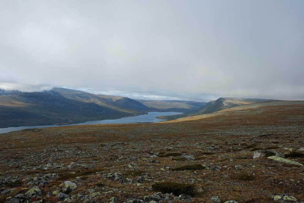
Killing time before homeward bound was done by climbing up to the summit of Veslfjellet. As most other walkers hiking over the Besseggen ridge are taking the boat to Memurubu and walking back to Gjendesheim I had thankfully escaped most of the throng doing the hike.

I had turned back just after the summit of Veslfjellet, with great views over Gjende surrounded by the jugged peaks of Jotunheimen, tempted to just continue down the edge of the Besseggen ridge.

Back at Gjendesheim, I sat down for a beer before I walked down to the campsite at Maurvangen where I had met the father and sons who also had stayed at the Oskampen cabin. One of the sons lived in Oslo, so I had been so fortunate to get a lift back home.

Cabin and boathouse at Gjendeosen.

Gjende.
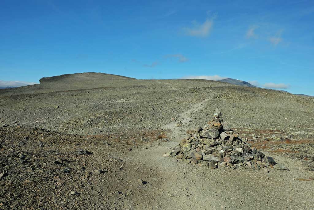
Up towards Veslfjellet on the stony plateau at its top.

Looking down at Gjende with Gjendehøe and Knutshøe behind.

Steep outcrop at Veslfjellet, with views down towards Gjendeosen and Gjendesheim below.

As I had struggled to come up with a trail that I really wanted to do this year, my motivation had suffered. Last year was no problem, it was obvious that I wanted to experience the pilgrim path in Norway to Trondheim, but there were no real alternatives left that I really felt interesting for this year.

I had considered doing the Østerdalsleden to Trondheim, but found that doing another pilgrimage to Trondheim was not what I wanted the most. In the end, I had come up with the plan to do both Jotunheimstien and Rondanestien after considering several other options. Which included a plan to make my own trail so to speak.

I had not been properly motivated for it.

So then my verdict should be seen with that in mind. In itself, each day had been nice, but in the end, they begun to feel the same. That said, I did not have a bad time on the trail.

As the trail had finally moved up into the mountains, things had improved, but the damage had been done.

However, one thing that remains with me after the hike is all the old farmsteads, both still in use and apparently abandoned, which I found particularly fascinating. Some with views, some secluded deep in the woods, all with histories probably to be told. The toil of old.

Jotunheimen.

Looking down at Gjende from Veslfjellet with the peaks of Jotunheim all around it, Bukkehåmåren and Høgdebrotet to the left.

A solitary red t waymarker in front of Bessvatnet with Bessfjellet behind.

Looking back towards Jotunheimstien on the way down from Veslfjellet, Sikkilsdalshøa in the background.

Old farms at Gjendeosen.

It is written that the Jotunheimstien trail is following the footsteps of old Norwegian writers and artists, maybe this is best seen through these old farmsteads along the way.

<< Gjende // day 12

Saturday, September 4, 2021

Jotunheimstien // day 12 // Oskampen - Gjende

Jotunheimstien, day 12.
Distance: 27.2km (346.0km).


It had been a beautiful morning to wake up to. Rime on the grass outside. Sun rising warm in the East. Mountains reflecting in the mirror calm lakes below. And cows looking stupidly at me just outside the windows.

The final day on the Jotunheimstien trail and its terminus at the Gjendesheim cabin, and at the end it was just as I had expected it to be. Seeing more people at once than I had combined on all the days on the trail. The price of being close to the hike everybody puts their pride in doing, Besseggen.

I had spent more time than usual after setting forth from Oskampen, the views had been too nice to walk quickly past them. It was quiet, and the clouds floating over Austhøi was perfectly reflected in the calm waters of the small lake nearby the cabin.

Those clouds floating over Austhøi had however continued their journey as I had hiked down to the cabins at Nedre Heimdalen and begun my climb up towards the highest point on the Jotunheimstien trail.

As I had hiked up towards the pass between Såta and Vangstulkampen, the clouds had almost covered my ascent and I had expected a foggy hike over the pass.

That did not happen and when I had crossed the highest point of the trail at approximately 1421m, I had great views of the landscape ahead. Still clouds around me of course.

At Sikkilsdalsseter with a view of the gathering of horses, I took a short break where I had treated me to a beer brewed by the hosts at the mountain farm.

Rime outside Oskampen.

Reflections of clouds drifting over Austhøi in the small lake outside the Oskampen cabin.

Nedre Heimdalsvatnet from the climb up towards Vangstulkampen.

At the highest point of the Jotunheimstien trail (although I was to be higher up at a later point).

Sikkilsdalen, Sikkilsdalshøa to the right.

After Sikkilsdalsseter it is where the intrepid hiker will meet an enigma of the trail. The sort of official route of the trail goes down alongside the two Sikkilsdalsvatnet lakes, but any with local knowledge of the area knows that the path going over Sikkilsdalshøa is by far the most spectacular of the two ways towards Gjende.

Faced with the dilemma of leaving the trail or not, having hiked the beautiful path over Sikkilsdalshøa before, I had still decided upon the higher ground.

The crossing over Sikkilsdalshøe was by far the highlight of the whole trail. I had ventured off the path to gaze down from the steep sides of the mountain, marvelling at the sheer drop I had looked down from.

At the summit, the views are of Gjende with Jotunheimen in all its glory behind. The words are about Besseggen, but this is a just as great a hike if not better, with fewer people.

Went through several herds of reindeers on the way down.

The final section had been as expected not so enticing, having walked through the campsite and up alongside the road (on the path though) towards the end of the trail at Gjende.

It was a little bit shock to the system to arrive at the Gjendesheim with all the people present, but I had been prepared for it. Irony being having to sit alone at the dinner table due to the still present corona rules.

A steep look down from the side of Sikkilsdalshøa.

Jotunheimene with Gjende from Sikkilsdalshøa.

Reindeers and Jotunheimen.

Reindeer.

At the end of the Jotunheimstien trail, the Gjendesheim cabin at Gjende.

I felt I had earned a good dinner and a good beer, having hiked from Oslo to Jotunheimen (although with a break in between).

<< Oskampen // day 11Veslfjellet // day 13 >>

Friday, September 3, 2021

Jotunheimstien // day 11 // Storkvolv - Oskampen

Jotunheimstien, day 11.
Distance: 26.4km (318.8km).


On the penultimate day on Jotunheimstien, I had walked to the Oskampen cabin.

The day had started all so unexpectedly, as I had woken up to a grey and shrouded weather outside, with imminent rain approaching. Quite contrary to the forecast I had received at Liomseter, which was for all good weather, but then again. Weather can change fast in the mountains.

Initially, I had been a little bit disgruntled when the rain had started, having felt annoyed that I should get the worst weather on the trail in the best part of it. I had, however, soon gotten over it and started enjoying my walk. Despite the low clouds and rain drifting across the landscape, the views were nice.

It even had added some dramatic flair to it.

I had hiked here before, some years ago, but in this weather, there were not much that I could remember from that time.

Storkvolvbua in the morning, last light before the rain.

Rain over Langsua.

An opening appears in the rain, revealing mountains in the distance.

Rainbow before Storhøpiggen and Storhøa.

Clouds and light, Brennhøa.

At least not until the rain had started abating and blue sky had pierced through the clouds, spawning rainbows over the Svarttjønn lake. Storhøpiggen (1434m) and Storhøa (1420m) lies behind and I remembered that I had walked between those two peaks in my previous hike here.

I had lunch at the DNT cabin in the old farm of Storhøliseter, while drying up a little after the rain. This is a cosy little cabin with a nice farmyard outside, overlooking the boggy expanse the trail crosses over afterwards.

Before the path reaches Øyangen, it traverses a section of bogs and marsh land, getting my shoes wet was unavoidable. Of the final walk to Oskampen, this had been the most memorable, as I had not felt that excited about the walk next to the Øyangen lake.

While I had walked next to the lake, I could see that it was still raining to the south of me. Here I had walked underneath the sun and it had got warm.

Crossing over Vinstra with Storhøliseter and Storhøpiggen behind.

On the path towards Øyangen.

Langtjønna.

Oskampen cabin.

Sunset at Oskampen.

Cows had watched my final steps to the cabin. And almost for the first time on the trail, there were other people where I was staying. A father with his two sons, all grown-ups, were also staying at the cabin, which made for a social evening (probably for the greater good, preparing me for the next evening, when I would be at the Gjendesheim cabin).

<< Storkvolv // day 10Gjende // day 12 >>

Thursday, September 2, 2021

Jotunheimstien // day 10 // Slivatnet - Storkvolv

Jotunheimstien, day 10.
Distance: 29.2km (292.4km).


The first day that I felt was a full day in the mountains, although there were sections of forests on this walk as well. At the end of the walk, I had again abandoned my tent and was located inside the Storkvolvbua cabin with the wind outside making the walls creak.

When the Jotunheimstien trail finally heads up into the mountains it will be the Vestfjell area it encounters first, before passing through Langsua National Park until the jagged peaks of Jotunheimen stands before the walker.

It had become a day of two halves. The first half consisted of the walk to the Liomseter staffed cabin and the second half of the walk from there to Storkvolvbua in Langsua.

An open area of bogs and wide views had greeted me after I had left Vestfjellhytta and the nearby mountain farm of Nysetra. Marking the beginning of another section of forest, was another old farm, the remote Grytlia.

Thankfully the walk through the forest had been dominated by mountain birch and no tall and dark trees.

Nysetra, with Vestfjellhytta in the background.

Grytlia.

Walking over Suluhø with the central massif of the Langsua National Park ahead.

View from the summit of Nordre Suluhø.

Lunch at Liomseter, cured meat and sour cream porridge, along with a local beer brew.

Before the descent to Liomseter, I had felt the wind in my hair again over Nordre Suluhø. In the far horizon, I had been able to discern the peaks of the Jotuns.

At Liomseter, another mountain cabin run by DNT, I had stopped for a long break. There was no need for a long break, but I had wanted to. After a couple of locally brewed beers and a plate of cured meat with sour cream porridge, I had begun my climb up into the higher reaches of Langsua.

Langsua might not be as spectacular as Jotunheimen or Rondane, adhering more to the term pleasant than strenuous and steep. It is still mountains and I felt more in my right element than I ever had on my hike so far.

Definitely the highlight of the trail so far, although the wind had given me some resistance.

As the sun had declined behind the mountain, I had descended the short walk down to the Storkvolvbua cabin. No one there except for me.

Going through mountain birch on the way up Vakkerlifjellet.

View from Langsua.

The path through Langsua.

Vietjønnet, Storhøpiggen and Storhøa behind.

Light before evening at Langsua.

As night had descended, I had not regretted staying at the cabin, sitting inside with candles lit and a good fire in the oven. Looking out the windows at the mountain beneath, listening to the wind playing songs with the wooden walls.

<< Slivatnet // day 9Oskampen // day 11 >>

Wednesday, September 1, 2021

Jotunheimstien // day 9 // Skjellbreida - Slivatnet

Jotunheimstien, day 9.
Distance: 30.3km (263.2km).


This cabin I had booked in advance prior to setting forth on the second part of my walk on Jotunheimstien. I had arrived at the Vestfjellhytta cabin pummeled by wind as my mood has gone better by the appearance of the first mountains on the trail.

It was a moment long awaited for when I finally could smell that peculiar clean air of the mountains, and had looked back over the woods, hills, and lakes that I had walked through earlier.

I had had no other choice but to climb up to the top of Gammelhans, one of the summits of the Skjellbreida mountain. No regret afterwards either. Not a major peak at any point, at 1066m, but had still been up in the mountains.

Although after having walked for a while in great spirit with the open views and blankets of heather around me, passing by the mountain farms of Nysetra, it was back to the woods and bogs again.

At Bentsetra, with nice views over Dokkfløyvatnet, I met two women trying to herd some cows on the run back to their enclosure.

View back from the climb up Skjellbreidafjellet.

At Skjellbreidafjellet.

Nysetra.

Dokkfløyvatnet.

A bridge after Kittilbua.

From the Kittilbua cabin, which was under maintenance, the trail had gone through a section denoted a cultural path. I had at that time felt slightly robbed of being in the mountains, but it had been a nice walk. First going past old farms, then through the woods, although there had been some confusion regarding where the path went.

I had walked looking longingly up at the mountains nearby, Ormtjønnkampen. Looking at my map and eagerly awaited climbing up Obleikhaugen, yearning for the views. At first, I had felt disappointing, but a lookout tower at the top saved the climb.

The lookout tower had felt a tiny bit wobbly, but the views was worth the wobbly feeling.

Woods had returned, but now mountain birch had started dominating. Wind had picked up and at the summit of Grytlifjellet (1055m) my hair was either in my eyes or flowing behind me depending on which way I gazed.

Vestfjellhytta is a relatively new, and modern, cabin. And by all means, it was nice, it just felt so big for one person, and I confess that a part of me would have wanted to stay in my tent instead.

Old mountain farm at Dokkfløy near Kittilbua, part of a mountain museum.

View from the top of the lookout tower at Obleikhaugen.

View from Grytlifjellet.

Sunset, Vestfjellhytta.

Eating dinner, bacalao, at Vestfjellhytta.

Still, I had a nice evening while the wind made sure of making sounds outside.

<< Skjellbreida // day 8Storkvolv // day 10 >>

popular posts