Weather: Mostly cloudy, some fog and a little bit of rain in the evening.
Morning dawns, with promises of a day in the clouds. There is a constant stream of clouds coming from the direction of Paektusan. After eating breakfast, we pack our gear into the minibus that will take us to the foot of the mountain, the starting point of our hike. It is another bumpy ride on uneven gravel tracks that brings us to the sacred mountain of Korea, but it is a pleasant ride anyway. We drive through pine and larch woods seemingly quiet and peaceful, then enter the highland plateau that we will be trekking through. The scenery is promising.

At the foot of Paektusan, the start of our hike in North Korea.
Around Paektusan the sky is a mix of clouds and blue sky, but draped across the mountain itself is a solid layer of clouds. We stop at a parking lot next to several trucks, loaded with Koreans who are eyeing us curiously. It is rather chilly and gusty, a cold wind is blowing down from the mountain, as we are quite high up. We fill up with water, take the obligatory group photo and then we head off. The group consists of two Australian women, Paula and Sinead, two Norwegian men, Jo and me, led by Roger from New Zealand. With us we have Mr. Hwang and Mr. Kim, the guides from the government, and two local guides, Mr. Hwang and Mr. Choi. Also accompanying us is a team of journalists from Associated Press, they will follow us on the first day of this inaugural trek in North Korea.

The group at the start of the hike. From left: Paula, Sinead, Roger, Jo and me.
What I feel is difficult to describe, it has been far from my mind that I would be able to go hiking here in North Korea.

View of the highland plateau below the mountain from the ascent of Paektusan.
The trail up towards the summit of Paektusan starts off on a cobbled road, which is winding ever upwards on the mountain in wide turns. The trail is not following the road all the time, instead cutting its way between sections of the road on stony paths with lots of loose rocks. This is however not the normal tourist way to the top, which goes on a funicular taking you up to the crest of the caldera above, from where there is a short walk up to the summit.

At the top of Paektusan, with Chonji lake below, China on the other side.
It is a relentless ascent, but fortunately the clouds are getting higher as we climb further upwards. In the same effort to improve the tourism in the area, they are constantly working to improve the facilities and sights at the mountain. Slogans too, as it appears. On the side of the mountain it is written "Holy mountain of the revolution" in large letters. Small yellow flowers are clinging to life in the barren scenery of the mountain.

Me and some of the guides on the hike at Paektusan, Mr. Hwang, a local guide, me and Mr. Kim.

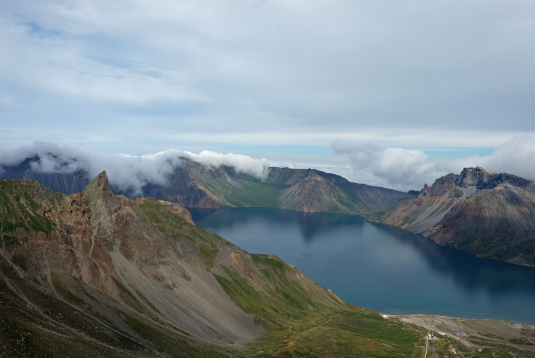
Another view of Paektusan with Chonji lake in the caldera.
At the crest of the caldera, we are met with a wonderful view of the mountain and the lake at the bottom of it, Chonji. Considering the low clouds hanging over the mountains earlier, we are exceptionally lucky to be able to witness this view too. The mountainsides running down the caldera is truly colorful, made so by the volcanic soil. Paektusan is an old volcano, with the highest point being the summit of Janggunbong at 2750m. The large crater, about 4km wide, that we see today was created when the volcano erupted in 946 (part of the volcanic debris was actually found in Greenland too). Guarding this side is numerous soldiers. It is far from quiet though, given the loud songs that are played to motivate the workers. It is a little bit surreal. Having walked around the crater a little bit and enjoying the scenery, we then gather to listen to a local guide telling us about the mountain. Only problem is that I can see clouds returning from China to cover the mountain again.

Janggungbong, the highest summit of Paektusan. Not long after this picture was taken, the summit was covered by clouds.

View down towards the tip of the caldera from the path up towards Janggunbong.
I am correct, just before we reach the summit, we and the mountain are covered by clouds. With this low visibility we are not allowed to climb to the highest point. I am tiny bit disappointed, naturally given my curious mind, but fact is that we would not have seen anything from there anyway, and I guess that we would not be allowed up anyway due to the strong winds. Disappointed or not, I am really happy to have seen the beautiful caldera and top of the mountain.

The long staircase leading down to Chonji lake.
A fun fact, the close proximity to China makes it possible for us to receive and send messages on our phones. In North Korea our phones will not work, but here we can get reception from China.
At the bottom of the crater lies Chonji, or Heaven Lake as it translates to. This is the deepest mountain lake in the world, with a maximum depth of 384 metres. From the lip of the caldera you can take a cable car down to the shore of the lake. The other way is to walk down on a very long staircase of stone, which we do. Climbing down, we descend underneath the clouds situated like a lid on top of the mountain. Coming out of the clouds, we can see the cable car, with excited screams when it suddenly swings in the air. By the sound of it, the ride must resemble something from a theme park.

Looking up towards Paektusan from Chonji lake, clouds hanging like a lid over the caldera, a cable car on the way down and a long line of stairs heading up into the clouds and mountain.

Chonji, or Heaven Lake, down at the bottom of the caldera. China on the other side of the lake.
It is a scenic spot, standing and looking out across the lake. I am still fascinated by the color display in the sides of the caldera. On the other side lies China. For South Koreans, that side is the only way for them to visit their sacred mountain. It feels sad in a way. Roger Shepherd has a hope that this hike could be seen as a part of a reunification of Korea. He is walking with what is called the reunification flag, which is white with an undivided Korea in blue without borders.

Two young Korean students at the shores of Chonji.
When we go to find a place for lunch, a group of young students arrive at the lake, filling up their waterbottles as is customary. The staff has been carrying our lunchboxes, sheer luxury. We get eggs, various vegetables including pickles, a sausage, some fish, some chicken, a bundle of tiny whole fish and lots of rice. Roger gets interviewed while we are eating. From above we can still hear excited screems from the people taking a ride in the cable car.

View from the shores of Chonji.
I do not count the steps as we climb up again to the fog and the mountain. At the top, a soldier escorts me across the terminus of the cable car. He is far from the stern faced soldier we would expect to meet, instead he is curious and while asking about me, he is also talking about Paektusan. Then I allow him to take my camera and take a picture of me (I cannot take a picture of him on the other hand).

Roger walking with the Korean reunification flag, blowing in the wind on the way up from Chonji.
With the mountain hidden even more in the clouds it is time to leave. We take the surprising way down. On a track going right next to the funicular. As we descend lower and lower down, the clouds opens up and lets us view more and more of the scenery that was hidden. Then I start to hear the wire used by the funicular begin to move. In the middle of one of the rickety bridges we have to cross, I can see the car coming down from the top. I reach safety in good time, but Paula and Rafael (one of the reporters from AP) just makes it across before it runs past them. I wave to the North Koreans in the funicular and they smiles and waves back at me. It was a fun walk down.

Descent from Paektusan going on a path right next to the funicular.
From the foot of the mountain we will be going to the place where we will be camping for the night. We walk past a couple of locals, most of them starting to laugh when we both tries to greet each other in English or Korean. The low clouds are making the scenery look like something out of Scotland, it resembles a heath, with green-gray undulating hills. A light drizzle is in the air. We pitch our tents down in a wadi, a dry stream bed. The staff has already arrived and pitched their tents and is preparing the dinner for the evening. The staff consists of Mr. Han, the driver, Mr. Kim (Big Kim) and a busdriver.

Narrow escape down the Paektusan funicular, Rafael and Paula looking at the car passing by after just coming off the bridge.

North Koreans greeting me from the passing funicular.
For dinner we get hot noodles with meat, and the sweet, soft, crunchy starbread to go with it. The driver has brought with him some homebrew made of blueberries, which is called duljjuk sul (blueberry wine). The evening is good and a nice end to this first hiking day in North Korea.

Fog on the North Korean heath below Paektusan.
Paektusan is a beautiful mountain, but it is almost only when you stand at the top of it that you truly understand why. It is also a very nice mountain from afar too, of course, but you need to climb it to see the true wonder of it. There are several tour operators that offers guided tours to the mountain, so if you are visiting North Korea and have time, you should be able to do so. The problem is its remote location and the only way to get there as a tourist is to fly to Samjiyon, there are only two flights a week. The mountain is also capricious when it comes to weather, so one cannot expect to arrive in good weather. I felt we were lucky to be able see the mountain given the weather we had today.

Dinner at our campsite below Paektusan. Mr. Hwang, Paula behind, Jo, Mr. Kim and Mr. Kim.
Even though climbing Paektusan was great, I do feel that the more special part of this hike begins tomorrow. As we then will be going hiking in an area few foreigners has been visiting.

My tent at the campsite in a dry riverbed below Paektusan.
<- Pyongyang & SamjiyonSoyeonjibong secret camp ->


Awesome mate! The APnews reporter's name is Rafael, not Ray.
ReplyDeleteThx, have changed it accordingly.
Delete