Kumano Kodo Iseji: the eastern route.
Fudarakusan-ji to Kumano Hongu Taisha (Hongu), 18th of October to 22th of October 2024.
Futamino-Ura to Kumano Hayatama Taisha (Shingu), 30th of October to 6th of November 2024.
Distance: 314.8km. 14 days.
One of the routes that is starting to increase in popularity is the Iseji, the eastern route. This is a route that for a long time has been less accessible to foreign walkers, as both maps, descriptions of the route and existing waymarks has only been in Japanese. This has now changed and a route that may have been on the verge of oblivion has resurfaced from memory. However, it must be stated that the route does not see as many walkers as on the Kohechi or Nakahechi route and that one might not meet others while hiking it.
Map of the Kumano Kodo routes with Iseji outlined.
Iseji connects Kumano Sanzan with another of the most important shrines in Japan, Ise Jingu, which is the main centre of worship of the sun goddess Amaterasu. It consists of an Inner Shrine (Naiku), dedicated to Amaterasu and an Outer Shrine (Geku), which is dedicated to Ukemochi, the goddess of food. Every 60 years the Inner Shrine is rebuilt from scratch due to an ancient custom.
Fudarakusan-ji, with a example of a boat that was used by the tokaisha to find the Pure Land of Fudaraku.
Outside Kumano, at the Hana-no-Iwaya shrine, Iseji splits into two branches. One turns inland towards Kumano Hongu Taisha and one follows the coast to Kumano Hayatama Taisha. However, Ise is not from where I start my walk on the Iseji. Instead it is from the Fudarakusan-ji shrine in Nachi-Katsuura, although the section from the shrine to Shingu is technically probably more a part of the Nakahechi or Ohechi than Iseji.
Ojigahama beach, looking dark underenath a sombre sky.
Fudarakusan-ji is an interesting shrine as it is known for the ritual called Fudaraku Tokai. In this ritual monks were sent out to the sea on a suicidal mission to find Fudaraku or Mount Potalak, the Pure Land, believed to be an island near the coast of Japan. Setting out to meet their fate in small boats designed to look like shrines, the monks became known as tokaisha, pilgrims of the sea.
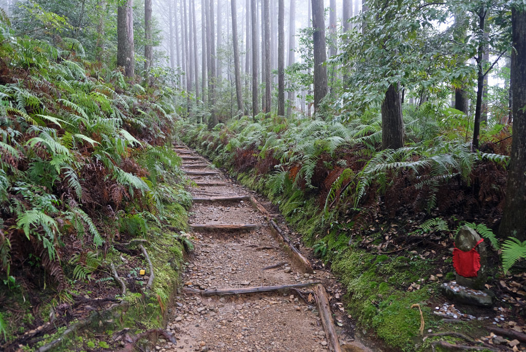
On the Onigajō walking trail outside of Kumano city.
The same sea is never far away when I walk on the Kumano Kodo to Kumano city from the temple, with walking on the long Shichiri-mihama beach, short but pleasant forest sections, a detour to an old whale hunting lookout spot with the nearby red Kinkoinari shrine in a verdant forest on the Koya-zaka slope, Hana-no-Iwaya shrine, Shishi-iwa rock, and orange juice tasting being the highlights of an otherwise less interesting walk. In the end, it is the hike around the Onigajō cliffs that comes out the best from the two days that I use to Kumano. A splendid walk on narrow stone paths and stairs past cave formations believed to be housing demons (Oni), although not a part of the Kumano Kodo.
The famous rice fields of Maruyama Senmaida.
Bear bells on the section of the Iseji between Kumano and Hongu. These big bells has been placed out so that hikers can warn bears or other animals of their coming, or play tunes on them if they are able to.
Demons or Oni they are not, but on the inland route towards Kumano Hongu Taisha I was thouroughly warned that there were bears around. Over the hills, through the woods and far away, people down in the valleys could probably follow my walk by hearing me trying to play a tune as I ring the large bells put out to announce the presence of a walker to the animals. The Japanese also often walk with a small bear bell hanging from their backpack, which can cause a tiny symphony when there are enough of them, but be cautious of how good an effect it really has.
Jizo at the Yojigawashurakuhaiji cemetery.
On the way to Kumano Hongu Taisha, I spend one day doing a loop in the area around Maruyama Senmaida. After visiting the famous rice fields, however, I enter a section of overgrown path where I manage to drop my phone. When I go back to search for it afterwards, I at first cannot find it. Seeing there is a rice field next to the path, now overgrown and full with water, I dread that the phone has fallen down into that ditch. When I drop down into the ditch to search for it, I manage to stick a pointed straw straight up my nose, causing me to instantly start to nosebleed. So there I am, fumbling through tall grass, water and what other things lurking about, looking for my phone while bleeding all over it and me. In the end, I find my phone tucked in deep underneath a bush back where I first believed to have lost it. At the ruins of the Akagi castle there is a public toilet where I could clean myself up and get something to raise my blood sugar level again from a vending machine. Best of all was returning to the wonderful Iruka Onsen Hotel Seiryuusou after the walk.
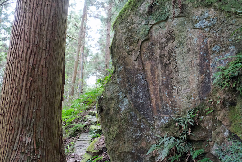
Inscriptions on a stone passed by on the way to the last pass of the Iseji before it joins the Nakahechi, which might be 'Namu Amida Butsu (I believe in Amida Butsu)'.
The Kumano Hongu Taisha Mikado gate.
Compared to the coastal route between Kumano And Shingu, the inland route to Hongu goes through a more rural scenery, and is a quieter and more exciting route, crossing over several passes on forest paths on the way. I spend the evening in Hongu before I take the bus to Inabane-oji to continue my Kumano Kodo journey on the Nakahechi as told in a previous article.
The Meoto-iwa wedded rocks at the Futami Okitama shrine outside Ise.
It is a dark and murky world outside when I take the train to Ise after having finished the Nakahechi, I am just happy to sit warm inside in the light as gloomy bays, hills and villages passes by the windows, knowing that in some days I would walk past those same bays, hills and villages. Hopefully in better weather.
Okage Yokocho in Ise, a street of old buildings now housing modern shops and restaurants.
Ise Jingu Geku, the outer shrine.
Although not a part of the Iseji, I opted to follow the walk Masako had tracked from the famous Meoto-iwa wedded rocks at the Futami Okitama jinja. Despite being less interesting before I arrive at the Asamagatake trailhead, it becomes a beautiful walk once climbing up into the mountains. I arrive at the Asamagatake Kongosho-ji temple walking through its alleyway of Sotoba wooden grave markers reaching from between two to eight metres in heigh. The top of Asamagatake provides heavy gusts of wind and great views of the sea and the Ise-Shima National Park. Down at the ancient streets of Okage Yokocho, I find myself at the original route of the Iseji.
Walking through rural areas and villages with tea bushes next to the path.
Having paid my respect for Amaterasu at the Ise Jingu, leaving Ise is a hike out of a city at the start, but then I get to the first pass (Meki-toge) and after that it is like I am stepping into another world. On the other side it is now rural with rice fields, rivers and small cozy villages wrapped in between mountains, spiced with green tea bushes next to the route.
A beaty spot on the Iseji, near the Sarugi-zaka slope one arrives at this scenic spot where one crosses the water on a makeshift bridge.
Another scenic spot, this is the view from the remains of the Mitsuse ferry, which the pilgrims back in time used to cross the river here.
When it comes to getting a place to stay for the night, I sort it out in the same way as when I had walked the Kiiji, by walking to a place with a train station from where I could get a train to my destination for the night. I also spend more than one night at some of the places.
Takiharanomiya shrine, a serene and peaceful place in the midst of a forest.
The route has its quirky parts. After Tochihara, the path crosses under the railroad and a road through a tunnel where hikers are advised to take the road if it is flooded. Masako had reported getting bitten by several leeches when she had walked through it when water was high, but there is no trouble when I get there. Only a string of interesting and scenic sections afterwards making use of small forested sections between the small villages. And then there is the boardwalk next to the Ouchiyama river after Taiki, with rusty leaves on its metallic floor, bearing hints of being forgotten.
The old Ouchi Yamanakagumi night light.
View from the Tsuzurato-toge pass, I was happy to reach this spot before the rain started for full.
After the Meki-toge pass, the Iseji follows an meandering valley slowly making its way towards to the ocean. On its course, the route crosses over some passes in the traditional vein of the Kumano Kodo like Sansezaka-toge before the impressive Takiharanomiya shrine. However, it is the Tsuzurato-toge that is the first pass to be the centre of the attention. Firstly, due to being the site of a bear attack only a month before I venture over it. Secondly due to the wonderful views from the top of the pass, and the steepness of its descent down towards Kihoku, marking the arrival of the route at the sea.
Dark and rainy clouds drifts in from the ocean of the coast of the Kii peninsula.
Rain hits, turning the path over the Miura-toge pass into a small creek.
Despite having planned for a long day with little leeway for excursions off the path, I am glad that I take the time to visit the Takiharanomiya shrine. Maybe it was due to the feeling that time itself could not enter the woods surrounding the impressive shrine. I could almost feel its absence as I walk through the natural alleyway between tall cedar trees, with old stone lamps and torii-gates leading to the tranquil Inner Shrine.
A wonderful walk on the climb up to the Magose-toge pass.
A beautiful sun shines through trees as I climb up the wonderful Magose-toge path. A stark contrast to the last part of the day before, where I felt I was back to the evening I took the train to Ise. Only that this time, I am outside the windows and not behind them. Out in the grey sea, cliffs stood headstrong in the torrent and the path over the Miura-toge pass turned into a series of fast-flowing small waterfalls.
A worthy detour, the (almost) summit of Tengurusan mountain before the descent to Owase.
Doi chikurin bamboo forest in Owase, reached through a small tunnel.
At Magose-toge, my only regret is not having time to visit the Elephant Rock of Binshiyama. Time had caught up with me again after losing it at the Takiharanomiya shrine. Instead, I make my way up to the top of Tengurusan, not a tall mountain in itself, but it offer great views over Owase below and out towards the sea. To get to the actual summit, which is a huge boulder, one has to climb up a metal ladder. Visit the Magose Fudo waterfall with shrine on the way down to Owase and experience an evening in a city that feels almost like being in the dark as it is when I am there.
Sakura no mori viewpoint of the sea and coast.
The route leaves Owase on an interesting path sneaking its way past the houses of the old town, one can visit the Kumano Kodo Centre located about 1km off the trail. I skip visiting the centre, only to probably waste the same amount of time visiting the Tenbō-no-oka viewpoint to cure my curiosity. A nice place, but the views are better later on the Kumano Kodo at the Sakura no Mori observation deck.
The green staircase on the Nigishima-toge and Okamizaka-toge pass section.
While still keeping the gnarled and mossy staircases of both stone and wood the Kumano Kodo is so famous for, with the green staircase on the Nigishima-toge and Okamizaka-toge pass section being my favourite, Iseji now passes by beaches, bays and small villages overlooking the ocean. Atashika is known in Japan for its beach and is a perfect spot for lunch and a dip in the ocean if the conditions are right.
Atashika beach.
I really enjoyed this day of walking past these small villages next to the sea, here Hadasucho village.
At the Obuki-toge pass, there is an option to walk the Kannon-michi instead. I opt for this alternative as I always has been fascinated by ruins. This route takes me to the site of the Hionzanseisuiji temple, which closed at the time of the second world war and is now a ruin. Despite not being that good waymarked, the route is wonderful, especially the descent towards Ōdomari past numerous Kannon statues.
The site of the ruins of the Hionzanseisuiji temple.
Yet another wonderful climb over a pass on a Kumano Kodo route, the Matsumoto-toge pass.
I finish the Iseji crossing over another nice pass, Matsumoto-toge, arriving once again in Kumano. This is where I at first had planned to end my walk on the Kumano Kodo after I changed my plans, but I felt that the proper ending should be at the Kumano Sanzan. I visit again the Shishi-iwa and Hana-no-Iwaya rock, before the long walk next to the Shichiri-mihama beach and end my walk at the Kumano Hayatama Taisha after 40 days and about 965 kilometres on the ancient routes of Kumano. In Shingu, I celebrate my finish eating my favourite Japanese dish, okonomiyaki, at a local restaurant.
Shishi-iwa lion rock outside Kumano City.
Wrapping it all up, Iseji became my definite favourite route of all of the Kumano Kodo. It felt in every essence more being on an adventure than the other routes. It contained all of those ancient paths that defines the Kumano Kodo, but it added so much more to the walk than that. Longer, more varied, more interesting, and more beautiful.
At the finishing line of my Kumano Kodo walks, Kumano Hayatama Taisha, having walked Kiiji, Kohechi, Ohechi, Nakahechi and Iseji.
Note: After finishing walking all the five main Kumano Kodo routes in Shingu, I spent some days in Kyoto and Tokyo as a regular tourist before flying back home to Norway.